Vizianagaram elevation
Vizianagaram (Andhra Pradesh, Vizianagaram District), India elevation is 66 meters and Vizianagaram elevation in feet is 217 ft above sea level [src 1]. Vizianagaram is a seat of a second-order administrative division (feature code) with elevation that is 227 meters (745 ft) smaller than average city elevation in India.
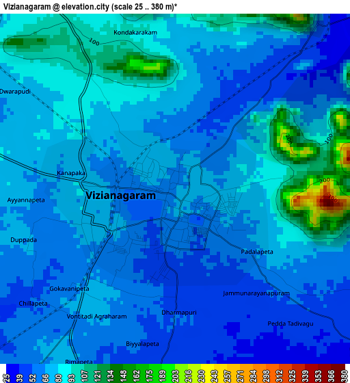
Below is the Elevation map of Vizianagaram, which displays elevation range with different colors. Scale of the first map is from 25 to 380 m (82 to 1247 ft) with average elevation of 72.7 meters (=239 ft) [note 1]
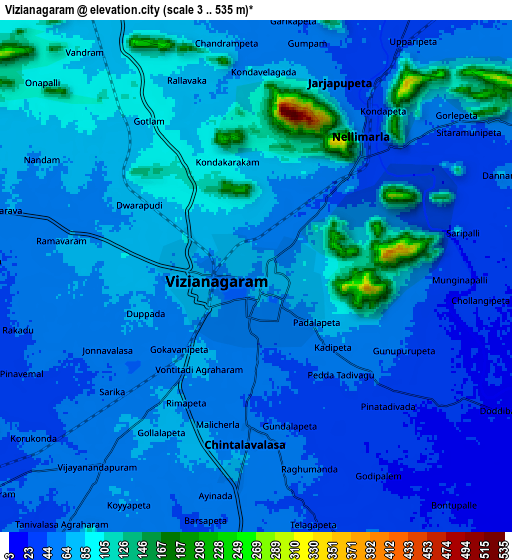
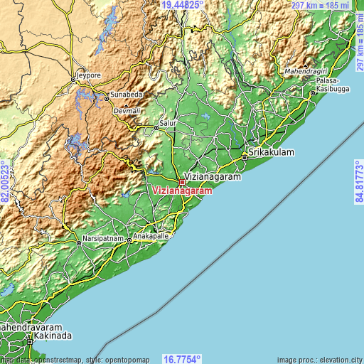
These maps also provides idea of topography and contour of this city, they are displayed at different zoom levels. More info about maps, scale and edge coordinates you can find below images.
| \ | Map #1 | Map #2 | Topo.Map |
| Scale [m] | 25..380 m | 3..535 m | × |
| Scale [ft] | 82..1247 ft | 10..1755 ft | × |
| Average | 72.7 m = 239 ft | 65.1 m = 214 ft | × |
| Width | 9.29 km = 5.8 mi | 18.58 km = 11.5 mi | 297.2 km = 184.7 mi |
| Height | 9.29 km = 5.8 mi | 18.58 km = 11.5 mi | 297.2 km = 184.7 mi |
| ↑Max Latitude | 18.158682° | 18.200433° | 19.44825° |
| Latitude at center | 18.11692° | 18.11692° | 18.11692° |
| ↓Min Latitude | 18.075148° | 18.033367° | 16.7754° |
| ← Min Longitude | 83.367535° | 83.323589° | 82.00523° |
| Longitude center | 83.41148° | 83.41148° | 83.41148° |
| →Max Longitude | 83.455425° | 83.499371° | 84.81773° |
Nearby cities:
Cities around Vizianagaram sort by population:
• Visakhapatnam elevation 24 m
53.4 km,  204°
204°
• Gajuwaka 17 m
50.7 km, 203°
• Srikakulam 14 m
55.2 km,  68°
68°
• Bobbili 135 m
51.1 km,  353°
353°
• Sālūr 160 m
49.5 km,  333°
333°
• Bhīmunipatnam 21 m
25.6 km,  170°
170°
• Amudālavalasa 36 m
61.3 km,  57°
57°
• Chodavaram 48 m
59.7 km,  237°
237°
• Rāzām 72 m
45.3 km,  35°
35°
• Vepagunta 54 m
43 km,  208°
208°
• Chīpurupalle 106 m
27.3 km, 37°
• Yārāda 10 m
53 km, 195°
Multilingual:
 En español:
Vizianagaram elevación 66 m.
 En France:
Vizianagaram élévation 66 m.
 Auf Deutsch:
Vizianagaram höhe über dem Meeresspiegel ist 66 m.

Sources and notes:
- [note 1] Map square and city borders are not equal. Map elevation data is calculated only from area inside that square.
- [src 1] Elevation data from geonames database provided with same terms of usage.
- [src 2] The elevation map of Vizianagaram is generated using elevation data from NASA's 3 arcsec (90m) resolution SRTM data.
- [src 3] Base (background) map © OpenStreetMap contributors tiles are generated by Geofabrik and OpenTopoMap.
Copyright & License:
This Vizianagaram Elevation Map is licensed under CC BY-SA. You may reuse any part from this page, if you give a proper credit by linking to this URL:
 More info on terms of use page.