Sālūr elevation
Sālūr (Andhra Pradesh, Vizianagaram District), India elevation is 160 meters and Sālūr elevation in feet is 525 ft above sea level [src 1]. Sālūr is a populated place (feature code) with elevation that is 133 meters (436 ft) smaller than average city elevation in India.
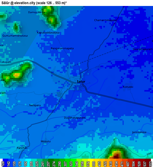
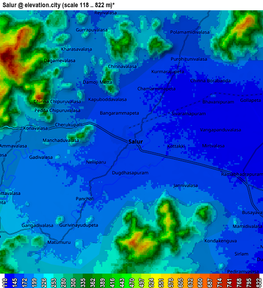
Below is the Elevation map of Sālūr, which displays elevation range with different colors. Scale of the first map is from 126 to 553 m (413 to 1814 ft) with average elevation of 167 meters (=548 ft) [note 1]
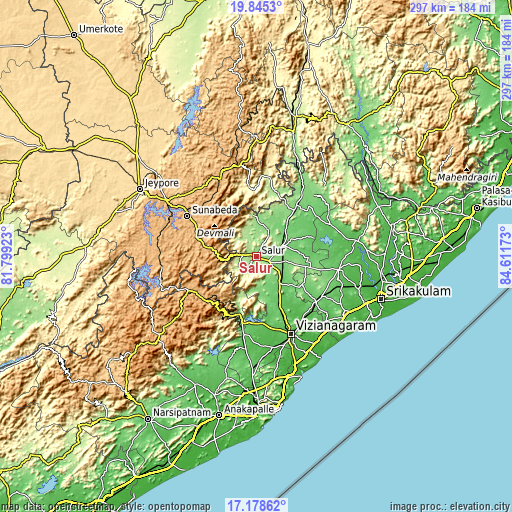
These maps also provides idea of topography and contour of this city, they are displayed at different zoom levels. More info about maps, scale and edge coordinates you can find below images.
| \ | Map #1 | Map #2 | Topo.Map |
| Scale [m] | 126..553 m | 118..822 m | × |
| Scale [ft] | 413..1814 ft | 387..2697 ft | × |
| Average | 167 m = 548 ft | 213.7 m = 701 ft | × |
| Width | 9.27 km = 5.8 mi | 18.53 km = 11.5 mi | 296.5 km = 184.2 mi |
| Height | 9.27 km = 5.8 mi | 18.53 km = 11.5 mi | 296.5 km = 184.2 mi |
| ↑Max Latitude | 18.558825° | 18.60048° | 19.8453° |
| Latitude at center | 18.51716° | 18.51716° | 18.51716° |
| ↓Min Latitude | 18.475485° | 18.433799° | 17.17862° |
| ← Min Longitude | 83.161535° | 83.117589° | 81.79923° |
| Longitude center | 83.20548° | 83.20548° | 83.20548° |
| →Max Longitude | 83.249425° | 83.293371° | 84.61173° |
Nearby cities:
Cities around Sālūr sort by population:
• Vizianagaram elevation 66 m
49.5 km,  153°
153°
• Srikakulam 14 m
76.9 km,  108°
108°
• Jeypore 592 m
76.7 km,  299°
299°
• Bobbili 135 m
17.4 km,  68°
68°
• Pārvatipuram 128 m
37.7 km,  38°
38°
• Bhīmunipatnam 21 m
74.4 km,  159°
159°
• Korāput 883 m
61.6 km, 302°
• Amudālavalasa 36 m
74.5 km,  99°
99°
• Pālkonda 52 m
58.8 km,  80°
80°
• Rāzām 72 m
48.5 km, 98°
• Chīpurupalle 106 m
44.6 km,  120°
120°
• Mādugula 97 m
78.5 km,  211°
211°
Multilingual:
 En español:
Sālūr elevación 160 m.
 En France:
Sālūr élévation 160 m.


Sources and notes:
- [note 1] Map square and city borders are not equal. Map elevation data is calculated only from area inside that square.
- [src 1] Elevation data from geonames database provided with same terms of usage.
- [src 2] The elevation map of Sālūr is generated using elevation data from NASA's 3 arcsec (90m) resolution SRTM data.
- [src 3] Base (background) map © OpenStreetMap contributors tiles are generated by Geofabrik and OpenTopoMap.
Copyright & License:
This Sālūr Elevation Map is licensed under CC BY-SA. You may reuse any part from this page, if you give a proper credit by linking to this URL:
 More info on terms of use page.