Kharhiāl elevation
Kharhiāl (Odisha, Nuapada), India elevation is 244 meters and Kharhiāl elevation in feet is 801 ft above sea level [src 1]. Kharhiāl is a populated place (feature code) with elevation that is 49 meters (161 ft) smaller than average city elevation in India.
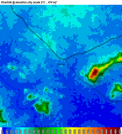
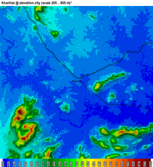
Below is the Elevation map of Kharhiāl, which displays elevation range with different colors. Scale of the first map is from 211 to 474 m (692 to 1555 ft) with average elevation of 241.7 meters (=793 ft) [note 1]
These maps also provides idea of topography and contour of this city, they are displayed at different zoom levels. More info about maps, scale and edge coordinates you can find below images.
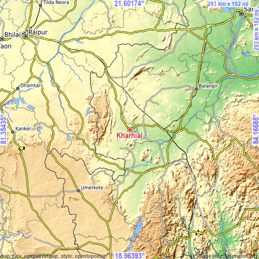
| \ | Map #1 | Map #2 | Topo.Map |
| Scale [m] | 211..474 m | 205..605 m | × |
| Scale [ft] | 692..1555 ft | 673..1985 ft | × |
| Average | 241.7 m = 793 ft | 256 m = 840 ft | × |
| Width | 9.17 km = 5.7 mi | 18.33 km = 11.4 mi | 293.3 km = 182.2 mi |
| Height | 9.17 km = 5.7 mi | 18.33 km = 11.4 mi | 293.3 km = 182.2 mi |
| ↑Max Latitude | 20.329663° | 20.370866° | 21.60174° |
| Latitude at center | 20.28845° | 20.28845° | 20.28845° |
| ↓Min Latitude | 20.247226° | 20.20599° | 18.96393° |
| ← Min Longitude | 82.716655° | 82.672709° | 81.35435° |
| Longitude center | 82.7606° | 82.7606° | 82.7606° |
| →Max Longitude | 82.804545° | 82.848491° | 84.16685° |
Nearby cities:
Cities around Kharhiāl sort by population:
• Balāngīr elevation 187 m
89 km,  58°
58°
• Bhawānipatna 259 m
60 km,  134°
134°
• Titlāgarh 217 m
40.9 km,  89°
89°
• Umarkot 615 m
90.3 km,  219°
219°
• Kantābānji 299 m
25.9 km,  39°
39°
• Patnāgarh 246 m
60.7 km, 39°
• Kesinga 195 m
49.2 km,  103°
103°
• Jūnāgarh 226 m
51 km,  159°
159°
• Padampur 200 m
85.1 km,  21°
21°
• Gariāband 348 m
82.2 km,  297°
297°
• Tarabha 134 m
107.2 km, 62°
• Khamharia 328 m
93 km,  325°
325°
Multilingual:
 En español:
Kharhiāl elevación 244 m.
 En France:
Kharhiāl élévation 244 m.
 Auf Deutsch:
Kharhiāl höhe über dem Meeresspiegel ist 244 m.

Sources and notes:
- [note 1] Map square and city borders are not equal. Map elevation data is calculated only from area inside that square.
- [src 1] Elevation data from geonames database provided with same terms of usage.
- [src 2] The elevation map of Kharhiāl is generated using elevation data from NASA's 3 arcsec (90m) resolution SRTM data.
- [src 3] Base (background) map © OpenStreetMap contributors tiles are generated by Geofabrik and OpenTopoMap.
Copyright & License:
This Kharhiāl Elevation Map is licensed under CC BY-SA. You may reuse any part from this page, if you give a proper credit by linking to this URL:
 More info on terms of use page.