Kondagaon elevation
Kondagaon (Chhattisgarh), India elevation is 597 meters and Kondagaon elevation in feet is 1959 ft above sea level [src 1]. Kondagaon is a seat of a second-order administrative division (feature code) with elevation that is 304 meters (997 ft) bigger than average city elevation in India.
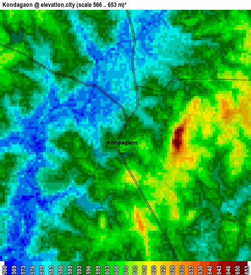
Below is the Elevation map of Kondagaon, which displays elevation range with different colors. Scale of the first map is from 566 to 653 m (1857 to 2142 ft) with average elevation of 594 meters (=1949 ft) [note 1]
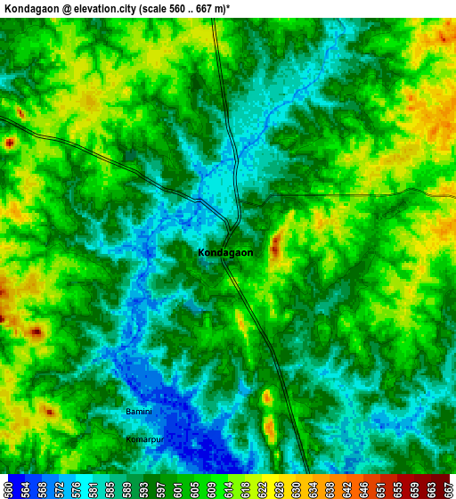
These maps also provides idea of topography and contour of this city, they are displayed at different zoom levels. More info about maps, scale and edge coordinates you can find below images.
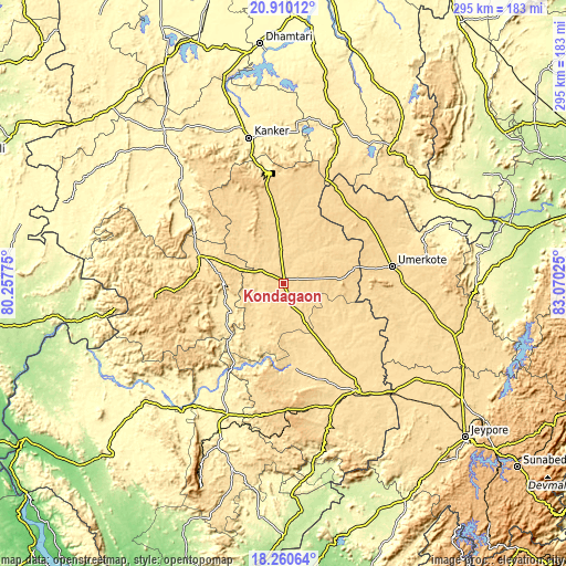
| \ | Map #1 | Map #2 | Topo.Map |
| Scale [m] | 566..653 m | 560..667 m | × |
| Scale [ft] | 1857..2142 ft | 1837..2188 ft | × |
| Average | 594 m = 1949 ft | 599.5 m = 1967 ft | × |
| Width | 9.21 km = 5.7 mi | 18.41 km = 11.4 mi | 294.6 km = 183.1 mi |
| Height | 9.21 km = 5.7 mi | 18.41 km = 11.4 mi | 294.6 km = 183.1 mi |
| ↑Max Latitude | 19.632226° | 19.673611° | 20.91012° |
| Latitude at center | 19.59083° | 19.59083° | 19.59083° |
| ↓Min Latitude | 19.549423° | 19.508006° | 18.26064° |
| ← Min Longitude | 81.620055° | 81.576109° | 80.25775° |
| Longitude center | 81.664° | 81.664° | 81.664° |
| →Max Longitude | 81.707945° | 81.751891° | 83.07025° |
Nearby cities:
Cities around Kondagaon sort by population:
• Nowrangapur elevation 578 m
101 km,  113°
113°
• Dhamtari 325 m
124.7 km,  354°
354°
• Jeypore 592 m
125.5 km,  130°
130°
• Jagdalpur 562 m
67.9 km,  146°
146°
• Umarkot 615 m
57.4 km,  81°
81°
• Kānker 401 m
77.8 km, 346°
• Kirandul 634 m
114.4 km,  201°
201°
• Kotapārh 561 m
85.4 km, 125°
• Gariāband 348 m
123.1 km,  19°
19°
• Narharpur 402 m
95.5 km,  357°
357°
• Gīdam 396 m
74 km, 202°
• Sukma 208 m
133.5 km,  180°
180°
Multilingual:
 En español:
Kondagaon elevación 597 m.
 En France:
Kondagaon élévation 597 m.
 Auf Deutsch:
Kondagaon höhe über dem Meeresspiegel ist 597 m.

Sources and notes:
- [note 1] Map square and city borders are not equal. Map elevation data is calculated only from area inside that square.
- [src 1] Elevation data from geonames database provided with same terms of usage.
- [src 2] The elevation map of Kondagaon is generated using elevation data from NASA's 3 arcsec (90m) resolution SRTM data.
- [src 3] Base (background) map © OpenStreetMap contributors tiles are generated by Geofabrik and OpenTopoMap.
Copyright & License:
This Kondagaon Elevation Map is licensed under CC BY-SA. You may reuse any part from this page, if you give a proper credit by linking to this URL:
 More info on terms of use page.