Jalapa elevation
Jalapa, Guatemala elevation is 1373 meters and Jalapa elevation in feet is 4505 ft above sea level [src 1]. Jalapa is a seat of a first-order administrative division (feature code) with elevation that is 106 meters (348 ft) bigger than average city elevation in Guatemala.
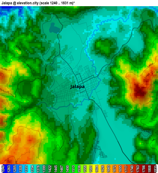
Below is the Elevation map of Jalapa, which displays elevation range with different colors. Scale of the first map is from 1240 to 1831 m (4068 to 6007 ft) with average elevation of 1446 meters (=4744 ft) [note 1]
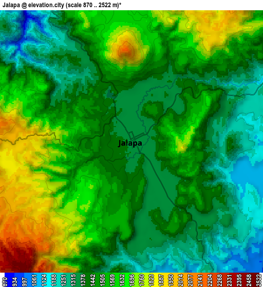
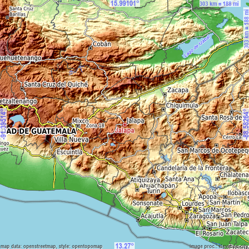
These maps also provides idea of topography and contour of this city, they are displayed at different zoom levels. More info about maps, scale and edge coordinates you can find below images.
| \ | Map #1 | Map #2 | Topo.Map |
| Scale [m] | 1240..1831 m | 870..2522 m | × |
| Scale [ft] | 4068..6007 ft | 2854..8274 ft | × |
| Average | 1446 m = 4744 ft | 1503.7 m = 4933 ft | × |
| Width | 9.46 km = 5.9 mi | 18.91 km = 11.8 mi | 302.5 km = 188 mi |
| Height | 9.46 km = 5.9 mi | 18.91 km = 11.8 mi | 302.6 km = 188 mi |
| ↑Max Latitude | 14.677235° | 14.719743° | 15.99101° |
| Latitude at center | 14.63472° | 14.63472° | 14.63472° |
| ↓Min Latitude | 14.592196° | 14.549664° | 13.27° |
| ← Min Longitude | -90.032835° | -90.076781° | -91.39514° |
| Longitude center | -89.98889° | -89.98889° | -89.98889° |
| →Max Longitude | -89.944945° | -89.900999° | -88.58264° |
Nearby cities:
Cities around Jalapa sort by population:
• Sanarate elevation 840 m
28.3 km,  307°
307°
• Guastatoya 520 m
25.9 km,  340°
340°
• Monjas 956 m
19.9 km,  138°
138°
• San Luis Jilotepeque 853 m
27.5 km,  86°
86°
• Mataquescuintla 1641 m
24.1 km,  240°
240°
• El Jícaro 248 m
32.8 km,  16°
16°
• Sansare 790 m
18.4 km, 312°
• San Pedro Pinula 1090 m
15.4 km,  76°
76°
• San Manuel Chaparrón 919 m
27.3 km,  118°
118°
• San Rafael Las Flores 1376 m
27 km,  229°
229°
• San Diego 705 m
27.6 km,  53°
53°
• San Carlos Alzatate 1767 m
17.1 km,  206°
206°
Multilingual:
 En español:
Jalapa elevación 1373 m.
 En France:
Jalapa élévation 1373 m.


Sources and notes:
- [note 1] Map square and city borders are not equal. Map elevation data is calculated only from area inside that square.
- [src 1] Elevation data from geonames database provided with same terms of usage.
- [src 2] The elevation map of Jalapa is generated using elevation data from NASA's 3 arcsec (90m) resolution SRTM data.
- [src 3] Base (background) map © OpenStreetMap contributors tiles are generated by Geofabrik and OpenTopoMap.
Copyright & License:
This Jalapa Elevation Map is licensed under CC BY-SA. You may reuse any part from this page, if you give a proper credit by linking to this URL:
 More info on terms of use page.