Monjas elevation
Monjas (Jalapa), Guatemala elevation is 956 meters and Monjas elevation in feet is 3136 ft above sea level [src 1]. Monjas is a seat of a second-order administrative division (feature code) with elevation that is 311 meters (1020 ft) smaller than average city elevation in Guatemala.
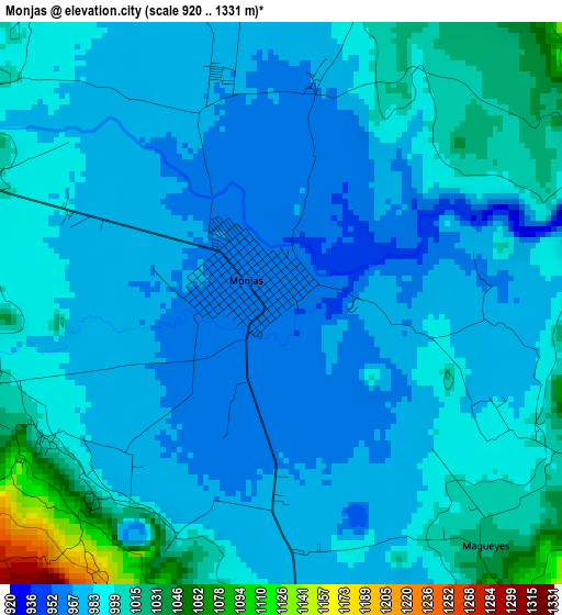
Below is the Elevation map of Monjas, which displays elevation range with different colors. Scale of the first map is from 920 to 1331 m (3018 to 4367 ft) with average elevation of 989.3 meters (=3246 ft) [note 1]
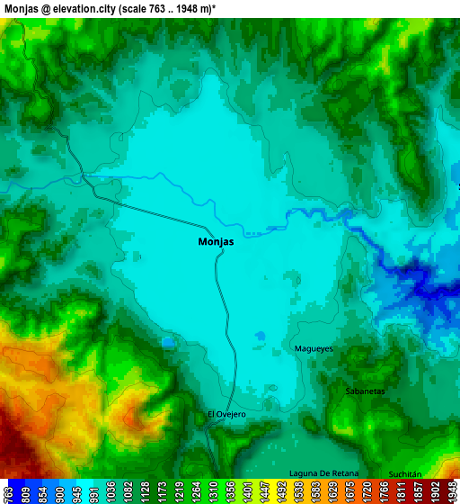
These maps also provides idea of topography and contour of this city, they are displayed at different zoom levels. More info about maps, scale and edge coordinates you can find below images.
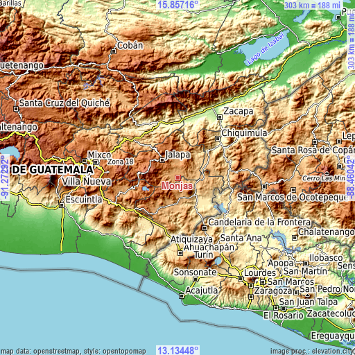
| \ | Map #1 | Map #2 | Topo.Map |
| Scale [m] | 920..1331 m | 763..1948 m | × |
| Scale [ft] | 3018..4367 ft | 2503..6391 ft | × |
| Average | 989.3 m = 3246 ft | 1112.4 m = 3650 ft | × |
| Width | 9.46 km = 5.9 mi | 18.92 km = 11.8 mi | 302.7 km = 188.1 mi |
| Height | 9.46 km = 5.9 mi | 18.92 km = 11.8 mi | 302.8 km = 188.2 mi |
| ↑Max Latitude | 14.542541° | 14.585075° | 15.85716° |
| Latitude at center | 14.5° | 14.5° | 14.5° |
| ↓Min Latitude | 14.45745° | 14.414893° | 13.13448° |
| ← Min Longitude | -89.910615° | -89.954561° | -91.27292° |
| Longitude center | -89.86667° | -89.86667° | -89.86667° |
| →Max Longitude | -89.822725° | -89.778779° | -88.46042° |
Nearby cities:
Cities around Monjas sort by population:
• Jalapa elevation 1373 m
19.9 km,  318°
318°
• Jutiapa 905 m
23.4 km,  187°
187°
• Asunción Mita 476 m
25.2 km,  138°
138°
• Santa Catarina Mita 752 m
13.7 km,  113°
113°
• San Luis Jilotepeque 853 m
22 km,  40°
40°
• El Progreso 962 m
16.8 km,  173°
173°
• Ipala 833 m
29.9 km,  64°
64°
• San Pedro Pinula 1090 m
18.6 km,  5°
5°
• Agua Blanca 892 m
23.3 km,  90°
90°
• San Manuel Chaparrón 919 m
10.9 km,  80°
80°
• Quesada 974 m
31.7 km,  216°
216°
• San Carlos Alzatate 1767 m
20.8 km,  269°
269°
Multilingual:
 En español:
Monjas elevación 956 m.
 En France:
Monjas élévation 956 m.


Sources and notes:
- [note 1] Map square and city borders are not equal. Map elevation data is calculated only from area inside that square.
- [src 1] Elevation data from geonames database provided with same terms of usage.
- [src 2] The elevation map of Monjas is generated using elevation data from NASA's 3 arcsec (90m) resolution SRTM data.
- [src 3] Base (background) map © OpenStreetMap contributors tiles are generated by Geofabrik and OpenTopoMap.
Copyright & License:
This Monjas Elevation Map is licensed under CC BY-SA. You may reuse any part from this page, if you give a proper credit by linking to this URL:
 More info on terms of use page.