Agua Blanca elevation
Agua Blanca (Jutiapa), Guatemala elevation is 892 meters and Agua Blanca elevation in feet is 2927 ft above sea level [src 1]. Agua Blanca is a seat of a second-order administrative division (feature code) with elevation that is 375 meters (1230 ft) smaller than average city elevation in Guatemala.
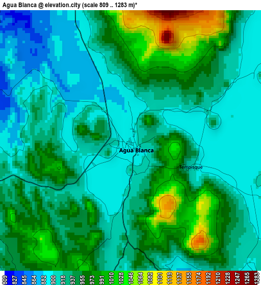
Below is the Elevation map of Agua Blanca, which displays elevation range with different colors. Scale of the first map is from 809 to 1283 m (2654 to 4209 ft) with average elevation of 939.8 meters (=3083 ft) [note 1]
These maps also provides idea of topography and contour of this city, they are displayed at different zoom levels. More info about maps, scale and edge coordinates you can find below images.
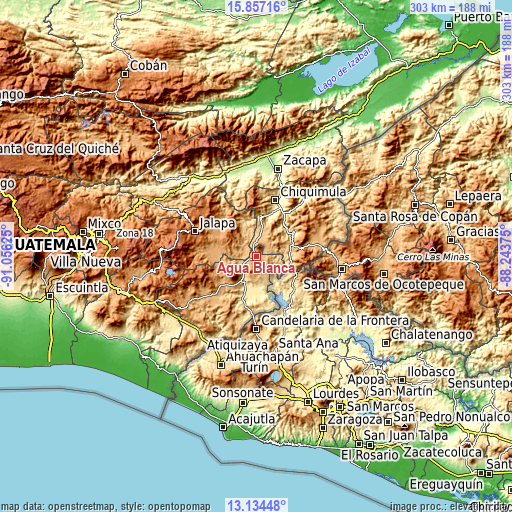
| \ | Map #1 | Topo.Map |
| Scale [m] | 809..1283 m | × |
| Scale [ft] | 2654..4209 ft | × |
| Average | 939.8 m = 3083 ft | × |
| Width | 9.46 km = 5.9 mi | 302.7 km = 188.1 mi |
| Height | 9.46 km = 5.9 mi | 302.8 km = 188.2 mi |
| ↑Max Latitude | 14.542541° | 15.85716° |
| Latitude at center | 14.5° | 14.5° |
| ↓Min Latitude | 14.45745° | 13.13448° |
| ← Min Longitude | -89.693945° | -91.05625° |
| Longitude center | -89.65° | -89.65° |
| →Max Longitude | -89.606055° | -88.24375° |
Nearby cities:
Cities around Agua Blanca sort by population:
• Asunción Mita elevation 476 m
19.9 km,  199°
199°
• Santa Catarina Mita 752 m
12.1 km,  242°
242°
• Monjas 956 m
23.3 km,  270°
270°
• San Luis Jilotepeque 853 m
18.9 km,  331°
331°
• El Progreso 962 m
27.2 km,  232°
232°
• Ipala 833 m
13.5 km,  15°
15°
• Quezaltepeque 700 m
26.9 km,  55°
55°
• San Pedro Pinula 1090 m
28.4 km,  310°
310°
• San Manuel Chaparrón 919 m
12.7 km,  278°
278°
• San José La Arada 442 m
25.1 km, 16°
• San Jacinto 534 m
24.6 km,  41°
41°
• Concepción Las Minas 773 m
20.9 km,  83°
83°
Multilingual:
 En español:
Agua Blanca elevación 892 m.
 En France:
Agua Blanca élévation 892 m.
 Auf Deutsch:
Agua Blanca höhe über dem Meeresspiegel ist 892 m.

Sources and notes:
- [note 1] Map square and city borders are not equal. Map elevation data is calculated only from area inside that square.
- [src 1] Elevation data from geonames database provided with same terms of usage.
- [src 2] The elevation map of Agua Blanca is generated using elevation data from NASA's 3 arcsec (90m) resolution SRTM data.
- [src 3] Base (background) map © OpenStreetMap contributors tiles are generated by Geofabrik and OpenTopoMap.
Copyright & License:
This Agua Blanca Elevation Map is licensed under CC BY-SA. You may reuse any part from this page, if you give a proper credit by linking to this URL:
 More info on terms of use page.