Asunción Mita elevation
Asunción Mita (Jutiapa), Guatemala elevation is 476 meters and Asunción Mita elevation in feet is 1562 ft above sea level [src 1]. Asunción Mita is a seat of a second-order administrative division (feature code) with elevation that is 791 meters (2595 ft) smaller than average city elevation in Guatemala.
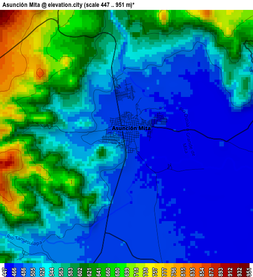
Below is the Elevation map of Asunción Mita, which displays elevation range with different colors. Scale of the first map is from 447 to 951 m (1467 to 3120 ft) with average elevation of 551.8 meters (=1810 ft) [note 1]
These maps also provides idea of topography and contour of this city, they are displayed at different zoom levels. More info about maps, scale and edge coordinates you can find below images.
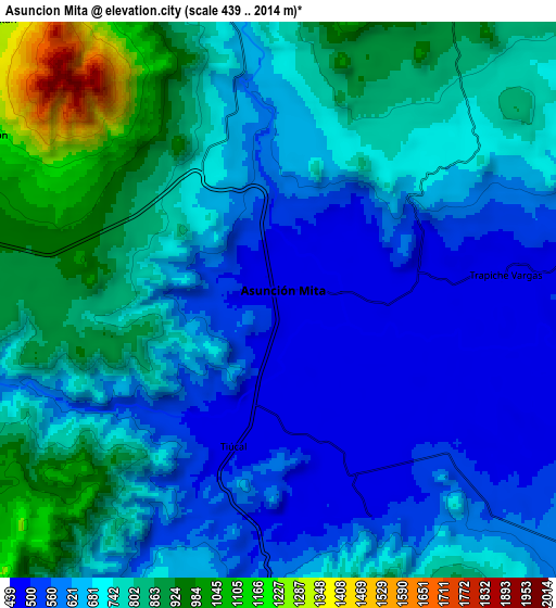
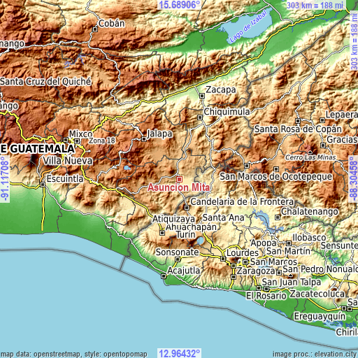
| \ | Map #1 | Map #2 | Topo.Map |
| Scale [m] | 447..951 m | 439..2014 m | × |
| Scale [ft] | 1467..3120 ft | 1440..6608 ft | × |
| Average | 551.8 m = 1810 ft | 707.9 m = 2323 ft | × |
| Width | 9.47 km = 5.9 mi | 18.94 km = 11.8 mi | 303 km = 188.3 mi |
| Height | 9.47 km = 5.9 mi | 18.94 km = 11.8 mi | 303 km = 188.3 mi |
| ↑Max Latitude | 14.373404° | 14.41597° | 15.68906° |
| Latitude at center | 14.33083° | 14.33083° | 14.33083° |
| ↓Min Latitude | 14.288248° | 14.245658° | 12.96432° |
| ← Min Longitude | -89.754775° | -89.798721° | -91.11708° |
| Longitude center | -89.71083° | -89.71083° | -89.71083° |
| →Max Longitude | -89.666885° | -89.622939° | -88.30458° |
Nearby cities:
Cities around Asunción Mita sort by population:
• Jutiapa elevation 905 m
20.4 km,  257°
257°
• Atescatempa 684 m
17.7 km,  191°
191°
• Santa Catarina Mita 752 m
13.9 km,  342°
342°
• Monjas 956 m
25.2 km,  318°
318°
• El Progreso 962 m
15.1 km,  278°
278°
• Jerez 732 m
26 km, 189°
• Yupiltepeque 1045 m
16.5 km,  208°
208°
• Agua Blanca 892 m
19.9 km,  19°
19°
• San Manuel Chaparrón 919 m
21.5 km, 343°
• El Adelanto 1188 m
22.5 km,  215°
215°
• Zapotitlán 867 m
25.6 km, 211°
• Comapa 1276 m
32.5 km, 222°
Multilingual:
 En español:
Asunción Mita elevación 476 m.
 En France:
Asunción Mita élévation 476 m.
 Auf Deutsch:
Asunción Mita höhe über dem Meeresspiegel ist 476 m.

Sources and notes:
- [note 1] Map square and city borders are not equal. Map elevation data is calculated only from area inside that square.
- [src 1] Elevation data from geonames database provided with same terms of usage.
- [src 2] The elevation map of Asunción Mita is generated using elevation data from NASA's 3 arcsec (90m) resolution SRTM data.
- [src 3] Base (background) map © OpenStreetMap contributors tiles are generated by Geofabrik and OpenTopoMap.
Copyright & License:
This Asunción Mita Elevation Map is licensed under CC BY-SA. You may reuse any part from this page, if you give a proper credit by linking to this URL:
 More info on terms of use page.