San Carlos Alzatate elevation
San Carlos Alzatate (Jalapa), Guatemala elevation is 1767 meters and San Carlos Alzatate elevation in feet is 5797 ft above sea level [src 1]. San Carlos Alzatate is a seat of a second-order administrative division (feature code) with elevation that is 500 meters (1640 ft) bigger than average city elevation in Guatemala.
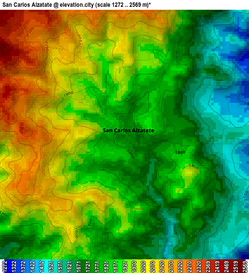
Below is the Elevation map of San Carlos Alzatate, which displays elevation range with different colors. Scale of the first map is from 1272 to 2569 m (4173 to 8428 ft) with average elevation of 1871 meters (=6138 ft) [note 1]
These maps also provides idea of topography and contour of this city, they are displayed at different zoom levels. More info about maps, scale and edge coordinates you can find below images.
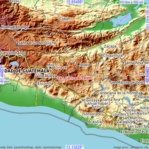
| \ | Map #1 | Topo.Map |
| Scale [m] | 1272..2569 m | × |
| Scale [ft] | 4173..8428 ft | × |
| Average | 1871 m = 6138 ft | × |
| Width | 9.46 km = 5.9 mi | 302.7 km = 188.1 mi |
| Height | 9.46 km = 5.9 mi | 302.8 km = 188.2 mi |
| ↑Max Latitude | 14.540322° | 15.85495° |
| Latitude at center | 14.49778° | 14.49778° |
| ↓Min Latitude | 14.45523° | 13.13225° |
| ← Min Longitude | -90.104225° | -91.46653° |
| Longitude center | -90.06028° | -90.06028° |
| →Max Longitude | -90.016335° | -88.65403° |
Nearby cities:
Cities around San Carlos Alzatate sort by population:
• Jalapa elevation 1373 m
17.1 km,  26°
26°
• Jutiapa 905 m
29 km,  142°
142°
• Monjas 956 m
20.8 km,  89°
89°
• Nueva Santa Rosa 1001 m
26.6 km,  240°
240°
• Casillas 1093 m
21.6 km,  246°
246°
• Mataquescuintla 1641 m
13.8 km,  284°
284°
• El Progreso 962 m
28 km,  125°
125°
• San José Acatempa 1346 m
26.8 km,  195°
195°
• Santa Rosa de Lima 948 m
28.1 km, 244°
• Sansare 790 m
28.2 km,  347°
347°
• San Rafael Las Flores 1376 m
13 km,  259°
259°
• Quesada 974 m
25.4 km,  175°
175°
Multilingual:
 En español:
San Carlos Alzatate elevación 1767 m.
 En France:
San Carlos Alzatate élévation 1767 m.
 Auf Deutsch:
San Carlos Alzatate höhe über dem Meeresspiegel ist 1767 m.
 На русском:
San Carlos Alzatate высота над уровнем моря 1767 м
Sources and notes:
- [note 1] Map square and city borders are not equal. Map elevation data is calculated only from area inside that square.
- [src 1] Elevation data from geonames database provided with same terms of usage.
- [src 2] The elevation map of San Carlos Alzatate is generated using elevation data from NASA's 3 arcsec (90m) resolution SRTM data.
- [src 3] Base (background) map © OpenStreetMap contributors tiles are generated by Geofabrik and OpenTopoMap.
Copyright & License:
This San Carlos Alzatate Elevation Map is licensed under CC BY-SA. You may reuse any part from this page, if you give a proper credit by linking to this URL:
 More info on terms of use page.