Sansare elevation
Sansare (El Progreso), Guatemala elevation is 790 meters and Sansare elevation in feet is 2592 ft above sea level [src 1]. Sansare is a seat of a second-order administrative division (feature code) with elevation that is 477 meters (1565 ft) smaller than average city elevation in Guatemala.
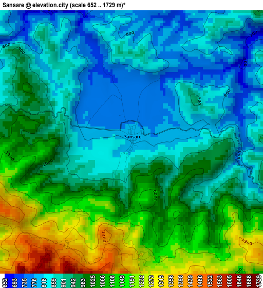
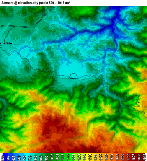
Below is the Elevation map of Sansare, which displays elevation range with different colors. Scale of the first map is from 652 to 1729 m (2139 to 5673 ft) with average elevation of 967.4 meters (=3174 ft) [note 1]
These maps also provides idea of topography and contour of this city, they are displayed at different zoom levels. More info about maps, scale and edge coordinates you can find below images.
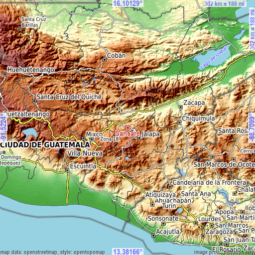
| \ | Map #1 | Map #2 | Topo.Map |
| Scale [m] | 652..1729 m | 529..1913 m | × |
| Scale [ft] | 2139..5673 ft | 1736..6276 ft | × |
| Average | 967.4 m = 3174 ft | 1075.5 m = 3529 ft | × |
| Width | 9.45 km = 5.9 mi | 18.9 km = 11.7 mi | 302.4 km = 187.9 mi |
| Height | 9.45 km = 5.9 mi | 18.9 km = 11.7 mi | 302.4 km = 187.9 mi |
| ↑Max Latitude | 14.788214° | 14.830699° | 16.10129° |
| Latitude at center | 14.74572° | 14.74572° | 14.74572° |
| ↓Min Latitude | 14.703218° | 14.660707° | 13.38166° |
| ← Min Longitude | -90.160095° | -90.204041° | -91.5224° |
| Longitude center | -90.11615° | -90.11615° | -90.11615° |
| →Max Longitude | -90.072205° | -90.028259° | -88.7099° |
Nearby cities:
Cities around Sansare sort by population:
• Jalapa elevation 1373 m
18.4 km,  132°
132°
• Palencia 1344 m
27.4 km,  251°
251°
• Sanarate 840 m
10.1 km,  298°
298°
• Guastatoya 520 m
13.1 km,  22°
22°
• San Agustín Acasaguastlán 327 m
27.8 km,  35°
35°
• San Antonio La Paz 1171 m
18.2 km,  274°
274°
• Mataquescuintla 1641 m
25.2 km,  196°
196°
• San José del Golfo 902 m
27.6 km, 274°
• El Jícaro 248 m
30 km,  50°
50°
• San Pedro Pinula 1090 m
29.9 km,  107°
107°
• Morazán 359 m
21 km,  352°
352°
• San Carlos Alzatate 1767 m
28.2 km,  167°
167°
Multilingual:
 En español:
Sansare elevación 790 m.
 En France:
Sansare élévation 790 m.


Sources and notes:
- [note 1] Map square and city borders are not equal. Map elevation data is calculated only from area inside that square.
- [src 1] Elevation data from geonames database provided with same terms of usage.
- [src 2] The elevation map of Sansare is generated using elevation data from NASA's 3 arcsec (90m) resolution SRTM data.
- [src 3] Base (background) map © OpenStreetMap contributors tiles are generated by Geofabrik and OpenTopoMap.
Copyright & License:
This Sansare Elevation Map is licensed under CC BY-SA. You may reuse any part from this page, if you give a proper credit by linking to this URL:
 More info on terms of use page.