Morazán elevation
Morazán (El Progreso), Guatemala elevation is 359 meters and Morazán elevation in feet is 1178 ft above sea level [src 1]. Morazán is a seat of a second-order administrative division (feature code) with elevation that is 908 meters (2979 ft) smaller than average city elevation in Guatemala.
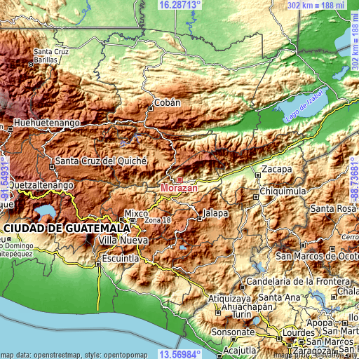
Below is the Elevation map of Morazán, which displays elevation range with different colors. Scale of the first map is from 294 to 1359 m (965 to 4459 ft) with average elevation of 541 meters (=1775 ft) [note 1]
These maps also provides idea of topography and contour of this city, they are displayed at different zoom levels. More info about maps, scale and edge coordinates you can find below images.

| \ | Map #1 | Topo.Map |
| Scale [m] | 294..1359 m | × |
| Scale [ft] | 965..4459 ft | × |
| Average | 541 m = 1775 ft | × |
| Width | 9.44 km = 5.9 mi | 302.1 km = 187.7 mi |
| Height | 9.44 km = 5.9 mi | 302.2 km = 187.8 mi |
| ↑Max Latitude | 14.975237° | 16.28713° |
| Latitude at center | 14.93278° | 14.93278° |
| ↓Min Latitude | 14.890315° | 13.56984° |
| ← Min Longitude | -90.187005° | -91.54931° |
| Longitude center | -90.14306° | -90.14306° |
| →Max Longitude | -90.099115° | -88.73681° |
Nearby cities:
Cities around Morazán sort by population:
• Salamá elevation 946 m
26.7 km,  315°
315°
• Sanarate 840 m
17.1 km,  200°
200°
• San Miguel Chicaj 945 m
32.4 km,  303°
303°
• Guastatoya 520 m
11.8 km,  137°
137°
• San Agustín Acasaguastlán 327 m
19 km,  84°
84°
• San Jerónimo 1001 m
17.6 km, 323°
• San Antonio La Paz 1171 m
24.6 km,  218°
218°
• San José del Golfo 902 m
31 km,  232°
232°
• Cabañas 247 m
36.9 km,  89°
89°
• El Jícaro 248 m
26.2 km, 93°
• Sansare 790 m
21 km,  172°
172°
• San Cristóbal Acasaguastlán 248 m
28 km, 93°
Multilingual:
 En español:
Morazán elevación 359 m.
 En France:
Morazán élévation 359 m.


Sources and notes:
- [note 1] Map square and city borders are not equal. Map elevation data is calculated only from area inside that square.
- [src 1] Elevation data from geonames database provided with same terms of usage.
- [src 2] The elevation map of Morazán is generated using elevation data from NASA's 3 arcsec (90m) resolution SRTM data.
- [src 3] Base (background) map © OpenStreetMap contributors tiles are generated by Geofabrik and OpenTopoMap.
Copyright & License:
This Morazán Elevation Map is licensed under CC BY-SA. You may reuse any part from this page, if you give a proper credit by linking to this URL:
 More info on terms of use page.