El Jícaro elevation
El Jícaro (El Progreso), Guatemala elevation is 248 meters and El Jícaro elevation in feet is 814 ft above sea level [src 1]. El Jícaro is a seat of a second-order administrative division (feature code) with elevation that is 1019 meters (3343 ft) smaller than average city elevation in Guatemala.
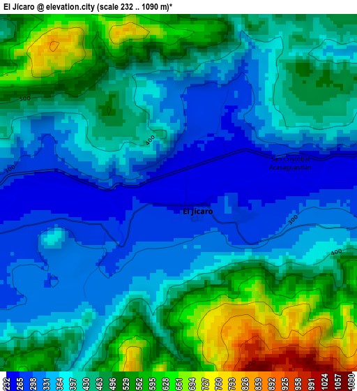
Below is the Elevation map of El Jícaro, which displays elevation range with different colors. Scale of the first map is from 232 to 1090 m (761 to 3576 ft) with average elevation of 430.2 meters (=1411 ft) [note 1]
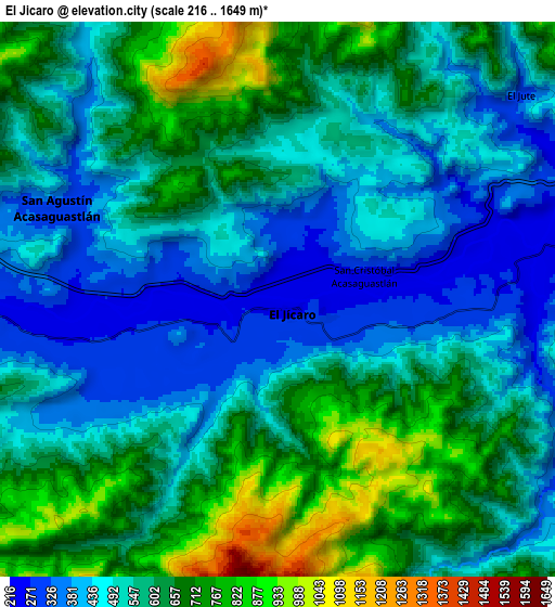
These maps also provides idea of topography and contour of this city, they are displayed at different zoom levels. More info about maps, scale and edge coordinates you can find below images.
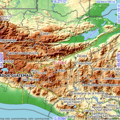
| \ | Map #1 | Map #2 | Topo.Map |
| Scale [m] | 232..1090 m | 216..1649 m | × |
| Scale [ft] | 761..3576 ft | 709..5410 ft | × |
| Average | 430.2 m = 1411 ft | 565.2 m = 1854 ft | × |
| Width | 9.44 km = 5.9 mi | 18.89 km = 11.7 mi | 302.2 km = 187.8 mi |
| Height | 9.44 km = 5.9 mi | 18.89 km = 11.7 mi | 302.2 km = 187.8 mi |
| ↑Max Latitude | 14.95913° | 15.001582° | 16.27112° |
| Latitude at center | 14.91667° | 14.91667° | 14.91667° |
| ↓Min Latitude | 14.874201° | 14.831724° | 13.55364° |
| ← Min Longitude | -89.943945° | -89.987891° | -91.30625° |
| Longitude center | -89.9° | -89.9° | -89.9° |
| →Max Longitude | -89.856055° | -89.812109° | -88.49375° |
Nearby cities:
Cities around El Jícaro sort by population:
• Jalapa elevation 1373 m
32.8 km,  196°
196°
• Guastatoya 520 m
19.5 km,  249°
249°
• San Agustín Acasaguastlán 327 m
8.1 km,  297°
297°
• Teculután 239 m
21 km,  69°
69°
• Usumatlán 236 m
13.1 km, 73°
• Cabañas 247 m
10.9 km,  80°
80°
• Sansare 790 m
30 km,  230°
230°
• San Pedro Pinula 1090 m
28.3 km,  169°
169°
• Huité 284 m
19.8 km, 84°
• Morazán 359 m
26.2 km,  273°
273°
• San Cristóbal Acasaguastlán 248 m
1.8 km,  90°
90°
• San Diego 705 m
19.4 km,  139°
139°
Multilingual:
 En español:
El Jícaro elevación 248 m.
 En France:
El Jícaro élévation 248 m.
 Auf Deutsch:
El Jícaro höhe über dem Meeresspiegel ist 248 m.

Sources and notes:
- [note 1] Map square and city borders are not equal. Map elevation data is calculated only from area inside that square.
- [src 1] Elevation data from geonames database provided with same terms of usage.
- [src 2] The elevation map of El Jícaro is generated using elevation data from NASA's 3 arcsec (90m) resolution SRTM data.
- [src 3] Base (background) map © OpenStreetMap contributors tiles are generated by Geofabrik and OpenTopoMap.
Copyright & License:
This El Jícaro Elevation Map is licensed under CC BY-SA. You may reuse any part from this page, if you give a proper credit by linking to this URL:
 More info on terms of use page.