Usumatlán elevation
Usumatlán (Zacapa), Guatemala elevation is 236 meters and Usumatlán elevation in feet is 774 ft above sea level [src 1]. Usumatlán is a seat of a second-order administrative division (feature code) with elevation that is 1031 meters (3383 ft) smaller than average city elevation in Guatemala.
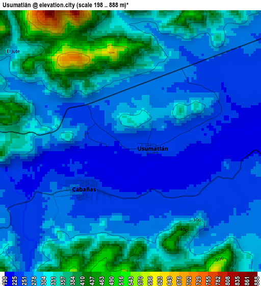
Below is the Elevation map of Usumatlán, which displays elevation range with different colors. Scale of the first map is from 198 to 888 m (650 to 2913 ft) with average elevation of 302.7 meters (=993 ft) [note 1]
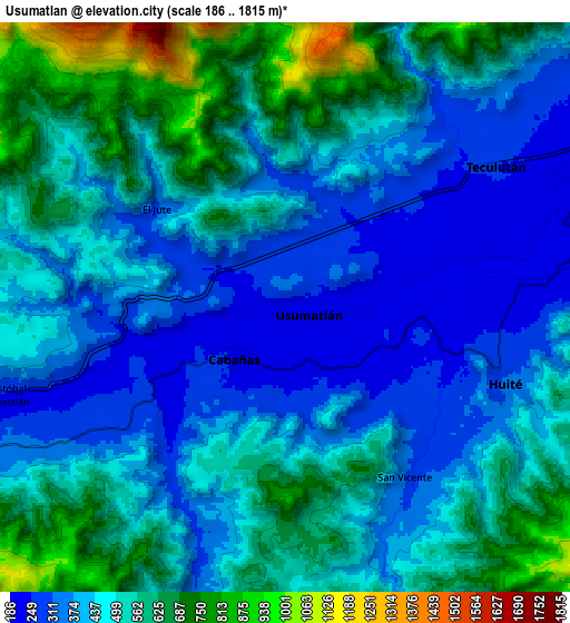
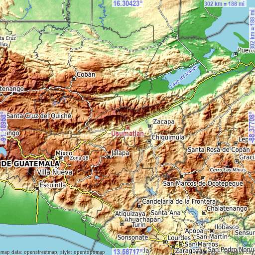
These maps also provides idea of topography and contour of this city, they are displayed at different zoom levels. More info about maps, scale and edge coordinates you can find below images.
| \ | Map #1 | Map #2 | Topo.Map |
| Scale [m] | 198..888 m | 186..1815 m | × |
| Scale [ft] | 650..2913 ft | 610..5955 ft | × |
| Average | 302.7 m = 993 ft | 478.3 m = 1569 ft | × |
| Width | 9.44 km = 5.9 mi | 18.88 km = 11.7 mi | 302.1 km = 187.7 mi |
| Height | 9.44 km = 5.9 mi | 18.88 km = 11.7 mi | 302.1 km = 187.7 mi |
| ↑Max Latitude | 14.992454° | 15.034899° | 16.30423° |
| Latitude at center | 14.95° | 14.95° | 14.95° |
| ↓Min Latitude | 14.907538° | 14.865068° | 13.58717° |
| ← Min Longitude | -89.827275° | -89.871221° | -91.18958° |
| Longitude center | -89.78333° | -89.78333° | -89.78333° |
| →Max Longitude | -89.739385° | -89.695439° | -88.37708° |
Nearby cities:
Cities around Usumatlán sort by population:
• Chiquimula elevation 425 m
30.5 km,  123°
123°
• Zacapa 231 m
27.3 km,  84°
84°
• San Agustín Acasaguastlán 327 m
19.7 km,  270°
270°
• Estanzuela 189 m
23.9 km, 76°
• Teculután 239 m
8.1 km,  62°
62°
• Río Hondo 528 m
25.1 km, 58°
• Cabañas 247 m
2.6 km,  224°
224°
• El Jícaro 248 m
13.1 km,  253°
253°
• Huité 284 m
7.4 km,  104°
104°
• San Cristóbal Acasaguastlán 248 m
11.4 km, 250°
• San Diego 705 m
18.5 km,  180°
180°
• San Jorge 252 m
21.6 km,  94°
94°
Multilingual:
 En español:
Usumatlán elevación 236 m.
 En France:
Usumatlán élévation 236 m.
 Auf Deutsch:
Usumatlán höhe über dem Meeresspiegel ist 236 m.

Sources and notes:
- [note 1] Map square and city borders are not equal. Map elevation data is calculated only from area inside that square.
- [src 1] Elevation data from geonames database provided with same terms of usage.
- [src 2] The elevation map of Usumatlán is generated using elevation data from NASA's 3 arcsec (90m) resolution SRTM data.
- [src 3] Base (background) map © OpenStreetMap contributors tiles are generated by Geofabrik and OpenTopoMap.
Copyright & License:
This Usumatlán Elevation Map is licensed under CC BY-SA. You may reuse any part from this page, if you give a proper credit by linking to this URL:
 More info on terms of use page.