Río Hondo elevation
Río Hondo (Zacapa), Guatemala elevation is 528 meters and Río Hondo elevation in feet is 1732 ft above sea level [src 1]. Río Hondo is a seat of a second-order administrative division (feature code) with elevation that is 739 meters (2425 ft) smaller than average city elevation in Guatemala.
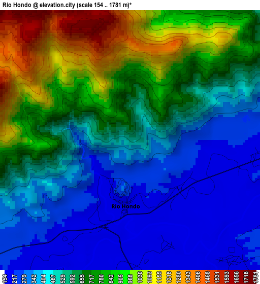
Below is the Elevation map of Río Hondo, which displays elevation range with different colors. Scale of the first map is from 154 to 1781 m (505 to 5843 ft) with average elevation of 598.4 meters (=1963 ft) [note 1]
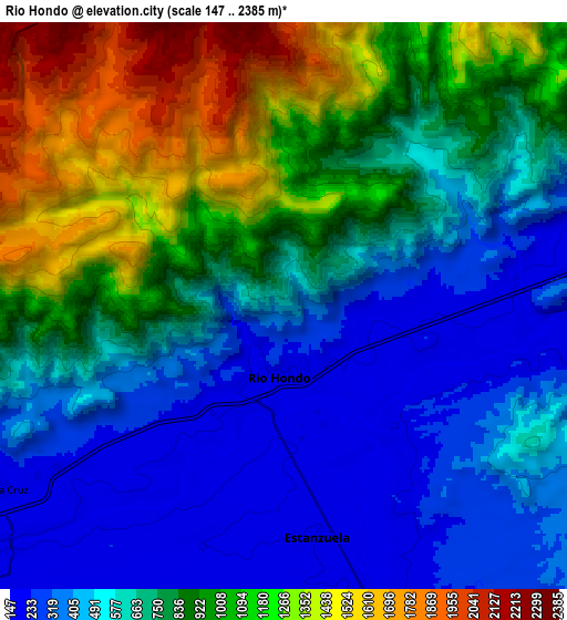
These maps also provides idea of topography and contour of this city, they are displayed at different zoom levels. More info about maps, scale and edge coordinates you can find below images.
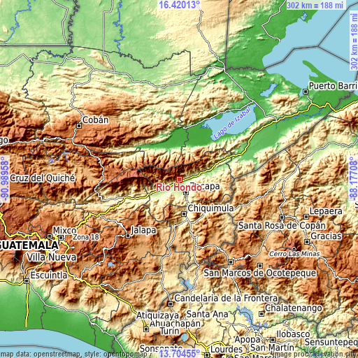
| \ | Map #1 | Map #2 | Topo.Map |
| Scale [m] | 154..1781 m | 147..2385 m | × |
| Scale [ft] | 505..5843 ft | 482..7825 ft | × |
| Average | 598.4 m = 1963 ft | 756.6 m = 2482 ft | × |
| Width | 9.44 km = 5.9 mi | 18.87 km = 11.7 mi | 301.9 km = 187.6 mi |
| Height | 9.44 km = 5.9 mi | 18.87 km = 11.7 mi | 302 km = 187.7 mi |
| ↑Max Latitude | 15.1091° | 15.151522° | 16.42013° |
| Latitude at center | 15.06667° | 15.06667° | 15.06667° |
| ↓Min Latitude | 15.024231° | 14.981784° | 13.70455° |
| ← Min Longitude | -89.627275° | -89.671221° | -90.98958° |
| Longitude center | -89.58333° | -89.58333° | -89.58333° |
| →Max Longitude | -89.539385° | -89.495439° | -88.17708° |
Nearby cities:
Cities around Río Hondo sort by population:
• Chiquimula elevation 425 m
29.9 km,  172°
172°
• Zacapa 231 m
11.9 km,  151°
151°
• Gualán 123 m
25 km,  76°
76°
• Estanzuela 189 m
7.6 km, 166°
• Teculután 239 m
17.1 km,  237°
237°
• Usumatlán 236 m
25.1 km, 238°
• Jocotán 435 m
34.3 km,  142°
142°
• Cabañas 247 m
27.6 km, 237°
• La Unión 994 m
33.4 km,  109°
109°
• Huité 284 m
20.6 km,  224°
224°
• Camotán 465 m
35.6 km, 140°
• San Jorge 252 m
14.8 km,  180°
180°
Multilingual:
 En español:
Río Hondo elevación 528 m.
 En France:
Río Hondo élévation 528 m.
 Auf Deutsch:
Río Hondo höhe über dem Meeresspiegel ist 528 m.

Sources and notes:
- [note 1] Map square and city borders are not equal. Map elevation data is calculated only from area inside that square.
- [src 1] Elevation data from geonames database provided with same terms of usage.
- [src 2] The elevation map of Río Hondo is generated using elevation data from NASA's 3 arcsec (90m) resolution SRTM data.
- [src 3] Base (background) map © OpenStreetMap contributors tiles are generated by Geofabrik and OpenTopoMap.
Copyright & License:
This Río Hondo Elevation Map is licensed under CC BY-SA. You may reuse any part from this page, if you give a proper credit by linking to this URL:
 More info on terms of use page.