Chiquimula elevation
Chiquimula, Guatemala elevation is 425 meters and Chiquimula elevation in feet is 1394 ft above sea level [src 1]. Chiquimula is a seat of a first-order administrative division (feature code) with elevation that is 842 meters (2762 ft) smaller than average city elevation in Guatemala.
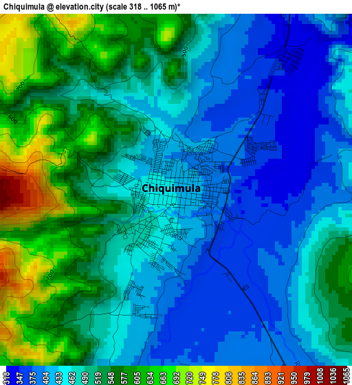
Below is the Elevation map of Chiquimula, which displays elevation range with different colors. Scale of the first map is from 318 to 1065 m (1043 to 3494 ft) with average elevation of 490.3 meters (=1609 ft) [note 1]
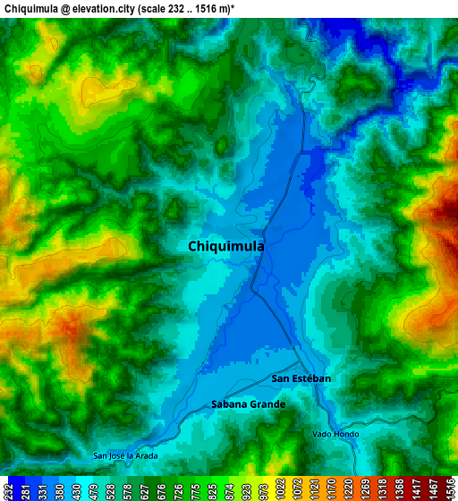
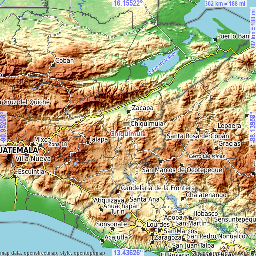
These maps also provides idea of topography and contour of this city, they are displayed at different zoom levels. More info about maps, scale and edge coordinates you can find below images.
| \ | Map #1 | Map #2 | Topo.Map |
| Scale [m] | 318..1065 m | 232..1516 m | × |
| Scale [ft] | 1043..3494 ft | 761..4974 ft | × |
| Average | 490.3 m = 1609 ft | 643 m = 2110 ft | × |
| Width | 9.45 km = 5.9 mi | 18.9 km = 11.7 mi | 302.3 km = 187.8 mi |
| Height | 9.45 km = 5.9 mi | 18.9 km = 11.7 mi | 302.3 km = 187.8 mi |
| ↑Max Latitude | 14.842483° | 14.884958° | 16.15522° |
| Latitude at center | 14.8° | 14.8° | 14.8° |
| ↓Min Latitude | 14.757508° | 14.715009° | 13.43626° |
| ← Min Longitude | -89.589775° | -89.633721° | -90.95208° |
| Longitude center | -89.54583° | -89.54583° | -89.54583° |
| →Max Longitude | -89.501885° | -89.457939° | -88.13958° |
Nearby cities:
Cities around Chiquimula sort by population:
• Zacapa elevation 231 m
19.2 km,  4°
4°
• Estanzuela 189 m
22.4 km,  354°
354°
• Ipala 833 m
21.8 km,  200°
200°
• Jocotán 435 m
16.9 km,  82°
82°
• Quezaltepeque 700 m
21.4 km,  148°
148°
• Huité 284 m
23.6 km,  308°
308°
• San José La Arada 442 m
10.1 km, 203°
• Olopa 1371 m
24.2 km,  119°
119°
• San Juan Ermita 602 m
13 km,  107°
107°
• Camotán 465 m
18.8 km, 83°
• San Jacinto 534 m
15.6 km,  161°
161°
• San Jorge 252 m
15.4 km,  344°
344°
Multilingual:
 En español:
Chiquimula elevación 425 m.
 En France:
Chiquimula élévation 425 m.
 Auf Deutsch:
Chiquimula höhe über dem Meeresspiegel ist 425 m.

Sources and notes:
- [note 1] Map square and city borders are not equal. Map elevation data is calculated only from area inside that square.
- [src 1] Elevation data from geonames database provided with same terms of usage.
- [src 2] The elevation map of Chiquimula is generated using elevation data from NASA's 3 arcsec (90m) resolution SRTM data.
- [src 3] Base (background) map © OpenStreetMap contributors tiles are generated by Geofabrik and OpenTopoMap.
Copyright & License:
This Chiquimula Elevation Map is licensed under CC BY-SA. You may reuse any part from this page, if you give a proper credit by linking to this URL:
 More info on terms of use page.