Palencia elevation
Palencia (Guatemala), Guatemala elevation is 1344 meters and Palencia elevation in feet is 4409 ft above sea level [src 1]. Palencia is a seat of a second-order administrative division (feature code) with elevation that is 77 meters (253 ft) bigger than average city elevation in Guatemala.
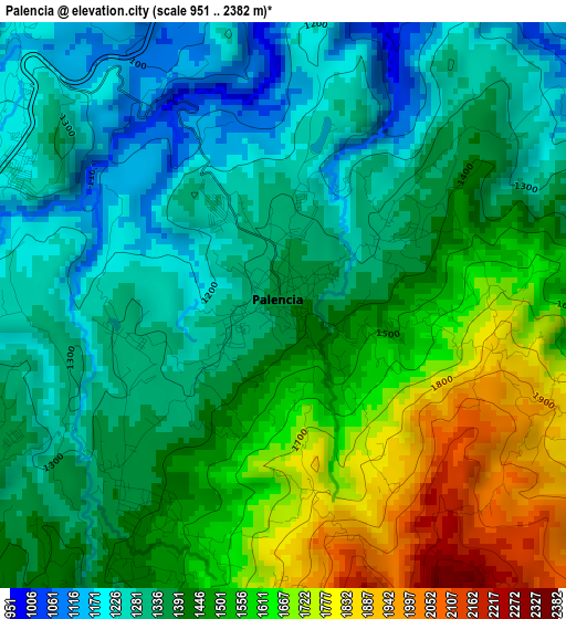
Below is the Elevation map of Palencia, which displays elevation range with different colors. Scale of the first map is from 951 to 2382 m (3120 to 7815 ft) with average elevation of 1434.3 meters (=4706 ft) [note 1]
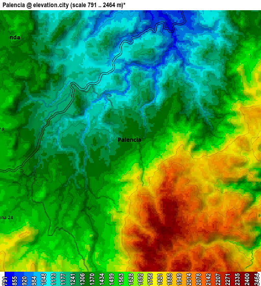
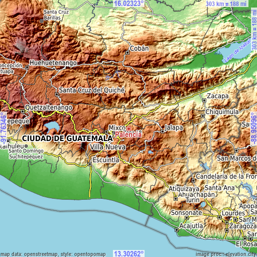
These maps also provides idea of topography and contour of this city, they are displayed at different zoom levels. More info about maps, scale and edge coordinates you can find below images.
| \ | Map #1 | Map #2 | Topo.Map |
| Scale [m] | 951..2382 m | 791..2464 m | × |
| Scale [ft] | 3120..7815 ft | 2595..8084 ft | × |
| Average | 1434.3 m = 4706 ft | 1490.6 m = 4890 ft | × |
| Width | 9.45 km = 5.9 mi | 18.91 km = 11.8 mi | 302.5 km = 188 mi |
| Height | 9.45 km = 5.9 mi | 18.91 km = 11.8 mi | 302.5 km = 188 mi |
| ↑Max Latitude | 14.709659° | 14.75216° | 16.02323° |
| Latitude at center | 14.66715° | 14.66715° | 14.66715° |
| ↓Min Latitude | 14.624633° | 14.582107° | 13.30262° |
| ← Min Longitude | -90.401155° | -90.445101° | -91.76346° |
| Longitude center | -90.35721° | -90.35721° | -90.35721° |
| →Max Longitude | -90.313265° | -90.269319° | -88.95096° |
Nearby cities:
Cities around Palencia sort by population:
• Guatemala City elevation 1508 m
17 km,  260°
260°
• Mixco 1692 m
27.2 km, 261°
• Chinautla 1233 m
15.8 km,  284°
284°
• Santa Catarina Pinula 1520 m
18.7 km,  234°
234°
• San José Pinula 1778 m
14.7 km,  203°
203°
• San Pedro Ayampuc 1192 m
16.2 km,  320°
320°
• Fraijanes 1641 m
24.2 km, 201°
• Sanarate 840 m
21.7 km,  51°
51°
• San Antonio La Paz 1171 m
12.8 km,  37°
37°
• Mataquescuintla 1641 m
24.1 km,  129°
129°
• Chuarrancho 1289 m
23.9 km,  314°
314°
• San José del Golfo 902 m
10.9 km,  351°
351°
Multilingual:
 En español:
Palencia elevación 1344 m.
 En France:
Palencia élévation 1344 m.
 Auf Deutsch:
Palencia höhe über dem Meeresspiegel ist 1344 m.

Sources and notes:
- [note 1] Map square and city borders are not equal. Map elevation data is calculated only from area inside that square.
- [src 1] Elevation data from geonames database provided with same terms of usage.
- [src 2] The elevation map of Palencia is generated using elevation data from NASA's 3 arcsec (90m) resolution SRTM data.
- [src 3] Base (background) map © OpenStreetMap contributors tiles are generated by Geofabrik and OpenTopoMap.
Copyright & License:
This Palencia Elevation Map is licensed under CC BY-SA. You may reuse any part from this page, if you give a proper credit by linking to this URL:
 More info on terms of use page.