Chuarrancho elevation
Chuarrancho (Guatemala), Guatemala elevation is 1289 meters and Chuarrancho elevation in feet is 4229 ft above sea level [src 1]. Chuarrancho is a seat of a second-order administrative division (feature code) with elevation that is 22 meters (72 ft) bigger than average city elevation in Guatemala.
Below is the Elevation map of Chuarrancho, which displays elevation range with different colors. Scale of the first map is from 680 to 1614 m (2231 to 5295 ft) with average elevation of 1144.2 meters (=3754 ft) [note 1]
These maps also provides idea of topography and contour of this city, they are displayed at different zoom levels. More info about maps, scale and edge coordinates you can find below images.
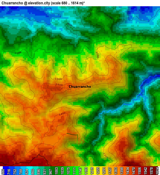
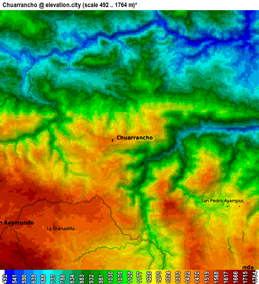
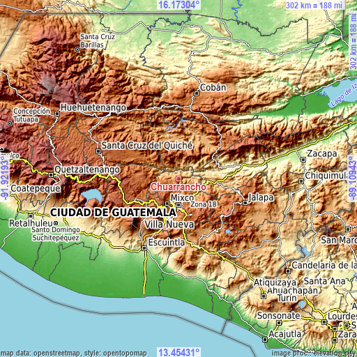
| \ | Map #1 | Map #2 | Topo.Map |
| Scale [m] | 680..1614 m | 492..1764 m | × |
| Scale [ft] | 2231..5295 ft | 1614..5787 ft | × |
| Average | 1144.2 m = 3754 ft | 1107.1 m = 3632 ft | × |
| Width | 9.45 km = 5.9 mi | 18.9 km = 11.7 mi | 302.3 km = 187.8 mi |
| Height | 9.45 km = 5.9 mi | 18.9 km = 11.7 mi | 302.3 km = 187.8 mi |
| ↑Max Latitude | 14.86042° | 14.902891° | 16.17304° |
| Latitude at center | 14.81794° | 14.81794° | 14.81794° |
| ↓Min Latitude | 14.775452° | 14.732956° | 13.45431° |
| ← Min Longitude | -90.559625° | -90.603571° | -91.92193° |
| Longitude center | -90.51568° | -90.51568° | -90.51568° |
| →Max Longitude | -90.471735° | -90.427789° | -89.10943° |
Nearby cities:
Cities around Chuarrancho sort by population:
• Guatemala City elevation 1508 m
19.7 km,  179°
179°
• Mixco 1692 m
23 km,  205°
205°
• San Juan Sacatepéquez 1842 m
17.7 km,  231°
231°
• Chinautla 1233 m
12.9 km,  172°
172°
• San Pedro Ayampuc 1192 m
8 km,  122°
122°
• Palencia 1344 m
23.9 km,  134°
134°
• San Pedro Sacatepéquez 2096 m
20 km,  222°
222°
• San Raimundo 1579 m
10.4 km,  235°
235°
• San José del Golfo 902 m
16.5 km,  111°
111°
• El Chol 1053 m
16.1 km,  10°
10°
• Pachalum 1227 m
19.8 km,  306°
306°
• Granados 936 m
11 km,  355°
355°
Multilingual:
 En español:
Chuarrancho elevación 1289 m.
 En France:
Chuarrancho élévation 1289 m.
 Auf Deutsch:
Chuarrancho höhe über dem Meeresspiegel ist 1289 m.

Sources and notes:
- [note 1] Map square and city borders are not equal. Map elevation data is calculated only from area inside that square.
- [src 1] Elevation data from geonames database provided with same terms of usage.
- [src 2] The elevation map of Chuarrancho is generated using elevation data from NASA's 3 arcsec (90m) resolution SRTM data.
- [src 3] Base (background) map © OpenStreetMap contributors tiles are generated by Geofabrik and OpenTopoMap.
Copyright & License:
This Chuarrancho Elevation Map is licensed under CC BY-SA. You may reuse any part from this page, if you give a proper credit by linking to this URL:
 More info on terms of use page.