Pachalum elevation
Pachalum (Quiché), Guatemala elevation is 1227 meters and Pachalum elevation in feet is 4026 ft above sea level [src 1]. Pachalum is a seat of a second-order administrative division (feature code) with elevation that is 40 meters (131 ft) smaller than average city elevation in Guatemala.
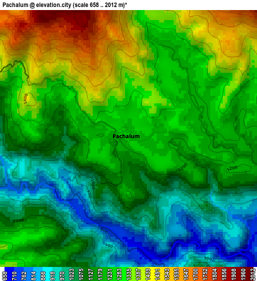
Below is the Elevation map of Pachalum, which displays elevation range with different colors. Scale of the first map is from 658 to 2012 m (2159 to 6601 ft) with average elevation of 1201.4 meters (=3942 ft) [note 1]
These maps also provides idea of topography and contour of this city, they are displayed at different zoom levels. More info about maps, scale and edge coordinates you can find below images.
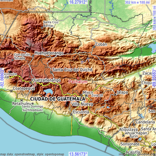
| \ | Map #1 | Topo.Map |
| Scale [m] | 658..2012 m | × |
| Scale [ft] | 2159..6601 ft | × |
| Average | 1201.4 m = 3942 ft | × |
| Width | 9.44 km = 5.9 mi | 302.1 km = 187.7 mi |
| Height | 9.44 km = 5.9 mi | 302.2 km = 187.8 mi |
| ↑Max Latitude | 14.967179° | 16.27912° |
| Latitude at center | 14.92472° | 14.92472° |
| ↓Min Latitude | 14.882253° | 13.56173° |
| ← Min Longitude | -90.706725° | -92.06903° |
| Longitude center | -90.66278° | -90.66278° |
| →Max Longitude | -90.618835° | -89.25653° |
Nearby cities:
Cities around Pachalum sort by population:
• San Juan Sacatepéquez elevation 1842 m
23 km,  175°
175°
• San Pedro Sacatepéquez 2096 m
26.6 km, 175°
• Joyabaj 1405 m
16.7 km,  297°
297°
• Rabinal 969 m
25.6 km,  45°
45°
• San Martín Jilotepeque 1728 m
21.3 km,  220°
220°
• Cubulco 1015 m
20.3 km,  10°
10°
• Zacualpa 1497 m
25.8 km, 296°
• Santo Domingo Xenacoj 1805 m
27.4 km,  188°
188°
• San Raimundo 1579 m
19.2 km,  157°
157°
• Chuarrancho 1289 m
19.8 km,  126°
126°
• El Chol 1053 m
19.2 km,  78°
78°
• Granados 936 m
15.1 km,  93°
93°
Multilingual:
 En español:
Pachalun elevación 1227 m.
 En France:
Pachalum élévation 1227 m.
 Auf Deutsch:
Pachalum höhe über dem Meeresspiegel ist 1227 m.

Sources and notes:
- [note 1] Map square and city borders are not equal. Map elevation data is calculated only from area inside that square.
- [src 1] Elevation data from geonames database provided with same terms of usage.
- [src 2] The elevation map of Pachalum is generated using elevation data from NASA's 3 arcsec (90m) resolution SRTM data.
- [src 3] Base (background) map © OpenStreetMap contributors tiles are generated by Geofabrik and OpenTopoMap.
Copyright & License:
This Pachalum Elevation Map is licensed under CC BY-SA. You may reuse any part from this page, if you give a proper credit by linking to this URL:
 More info on terms of use page.