Zacualpa elevation
Zacualpa (Quiché), Guatemala elevation is 1497 meters and Zacualpa elevation in feet is 4911 ft above sea level [src 1]. Zacualpa is a seat of a second-order administrative division (feature code) with elevation that is 230 meters (755 ft) bigger than average city elevation in Guatemala.
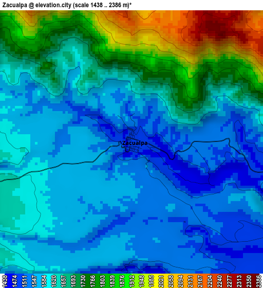
Below is the Elevation map of Zacualpa, which displays elevation range with different colors. Scale of the first map is from 1438 to 2386 m (4718 to 7828 ft) with average elevation of 1649.9 meters (=5413 ft) [note 1]
These maps also provides idea of topography and contour of this city, they are displayed at different zoom levels. More info about maps, scale and edge coordinates you can find below images.
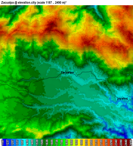
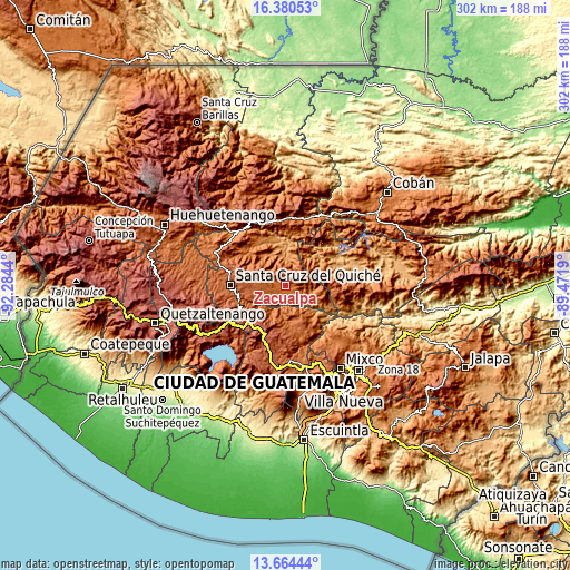
| \ | Map #1 | Map #2 | Topo.Map |
| Scale [m] | 1438..2386 m | 1187..2490 m | × |
| Scale [ft] | 4718..7828 ft | 3894..8169 ft | × |
| Average | 1649.9 m = 5413 ft | 1754.4 m = 5756 ft | × |
| Width | 9.44 km = 5.9 mi | 18.88 km = 11.7 mi | 302 km = 187.7 mi |
| Height | 9.44 km = 5.9 mi | 18.88 km = 11.7 mi | 302 km = 187.7 mi |
| ↑Max Latitude | 15.069248° | 15.111678° | 16.38053° |
| Latitude at center | 15.02681° | 15.02681° | 15.02681° |
| ↓Min Latitude | 14.984363° | 14.941908° | 13.66444° |
| ← Min Longitude | -90.922095° | -90.966041° | -92.2844° |
| Longitude center | -90.87815° | -90.87815° | -90.87815° |
| →Max Longitude | -90.834205° | -90.790259° | -89.4719° |
Nearby cities:
Cities around Zacualpa sort by population:
• Chichicastenango elevation 2049 m
26.7 km,  249°
249°
• Joyabaj 1405 m
9 km,  114°
114°
• San Martín Jilotepeque 1728 m
28.9 km,  161°
161°
• Cubulco 1015 m
28.1 km,  72°
72°
• San José Poaquil 1936 m
23.5 km,  189°
189°
• Chinique 1924 m
16 km,  275°
275°
• Chiché 2009 m
20 km,  264°
264°
• Santa Apolonia 2309 m
28.2 km,  201°
201°
• Pachalum 1227 m
25.8 km,  116°
116°
• San Andrés Sajcabajá 1252 m
18 km,  337°
337°
• Canillá 1252 m
15.7 km,  10°
10°
• San Bartolomé Jocotenango 1541 m
28.2 km,  310°
310°
Multilingual:
 En español:
Zacualpa elevación 1497 m.
 En France:
Zacualpa élévation 1497 m.
 Auf Deutsch:
Zacualpa höhe über dem Meeresspiegel ist 1497 m.

Sources and notes:
- [note 1] Map square and city borders are not equal. Map elevation data is calculated only from area inside that square.
- [src 1] Elevation data from geonames database provided with same terms of usage.
- [src 2] The elevation map of Zacualpa is generated using elevation data from NASA's 3 arcsec (90m) resolution SRTM data.
- [src 3] Base (background) map © OpenStreetMap contributors tiles are generated by Geofabrik and OpenTopoMap.
Copyright & License:
This Zacualpa Elevation Map is licensed under CC BY-SA. You may reuse any part from this page, if you give a proper credit by linking to this URL:
 More info on terms of use page.