Chichicastenango elevation
Chichicastenango (Quiché), Guatemala elevation is 2049 meters and Chichicastenango elevation in feet is 6722 ft above sea level [src 1]. Chichicastenango is a seat of a second-order administrative division (feature code) with elevation that is 782 meters (2566 ft) bigger than average city elevation in Guatemala.
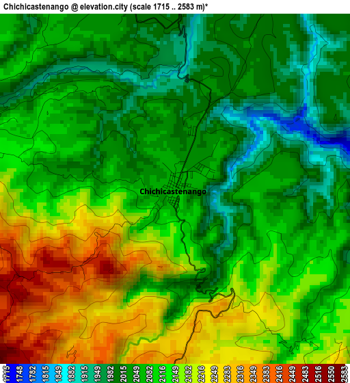
Below is the Elevation map of Chichicastenango, which displays elevation range with different colors. Scale of the first map is from 1715 to 2583 m (5627 to 8474 ft) with average elevation of 2102.9 meters (=6899 ft) [note 1]
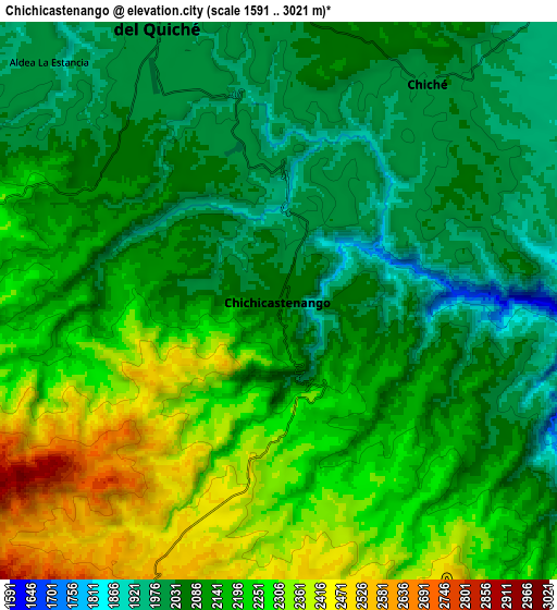
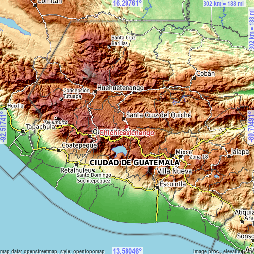
These maps also provides idea of topography and contour of this city, they are displayed at different zoom levels. More info about maps, scale and edge coordinates you can find below images.
| \ | Map #1 | Map #2 | Topo.Map |
| Scale [m] | 1715..2583 m | 1591..3021 m | × |
| Scale [ft] | 5627..8474 ft | 5220..9911 ft | × |
| Average | 2102.9 m = 6899 ft | 2150.7 m = 7056 ft | × |
| Width | 9.44 km = 5.9 mi | 18.88 km = 11.7 mi | 302.1 km = 187.7 mi |
| Height | 9.44 km = 5.9 mi | 18.88 km = 11.7 mi | 302.1 km = 187.7 mi |
| ↑Max Latitude | 14.985785° | 15.028231° | 16.29761° |
| Latitude at center | 14.94333° | 14.94333° | 14.94333° |
| ↓Min Latitude | 14.900867° | 14.858395° | 13.58046° |
| ← Min Longitude | -91.155105° | -91.199051° | -92.51741° |
| Longitude center | -91.11116° | -91.11116° | -91.11116° |
| →Max Longitude | -91.067215° | -91.023269° | -89.70491° |
Nearby cities:
Cities around Chichicastenango sort by population:
• Sololá elevation 2126 m
20.5 km,  202°
202°
• Santa Cruz del Quiché 2023 m
10.5 km,  337°
337°
• Panajachel 1612 m
22.9 km,  192°
192°
• Concepción 2072 m
18.1 km, 192°
• Chinique 1924 m
14.2 km,  39°
39°
• San Andrés Semetabaj 1861 m
22.2 km, 186°
• Chiché 2009 m
8.9 km,  34°
34°
• Santa Apolonia 2309 m
22.6 km,  138°
138°
• San Antonio Ilotenango 1946 m
17.8 km,  314°
314°
• San Pédro Jocopilas 2140 m
17.4 km,  345°
345°
• Patzité 2300 m
10.6 km,  282°
282°
• San José Chacayá 2177 m
22.2 km,  210°
210°
Multilingual:
 En español:
Chichicastenango elevación 2049 m.
 En France:
Chichicastenango élévation 2049 m.
 Auf Deutsch:
Chichicastenango höhe über dem Meeresspiegel ist 2049 m.

Sources and notes:
- [note 1] Map square and city borders are not equal. Map elevation data is calculated only from area inside that square.
- [src 1] Elevation data from geonames database provided with same terms of usage.
- [src 2] The elevation map of Chichicastenango is generated using elevation data from NASA's 3 arcsec (90m) resolution SRTM data.
- [src 3] Base (background) map © OpenStreetMap contributors tiles are generated by Geofabrik and OpenTopoMap.
Copyright & License:
This Chichicastenango Elevation Map is licensed under CC BY-SA. You may reuse any part from this page, if you give a proper credit by linking to this URL:
 More info on terms of use page.