Patzité elevation
Patzité (Quiché), Guatemala elevation is 2300 meters and Patzité elevation in feet is 7546 ft above sea level [src 1]. Patzité is a seat of a second-order administrative division (feature code) with elevation that is 1033 meters (3389 ft) bigger than average city elevation in Guatemala.
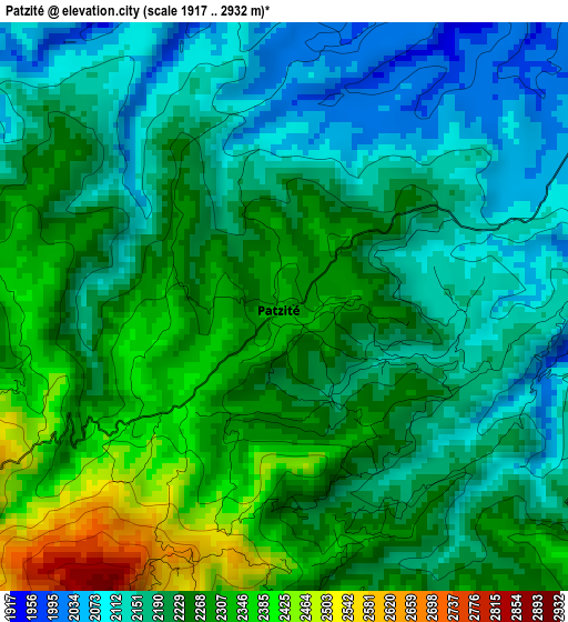
Below is the Elevation map of Patzité, which displays elevation range with different colors. Scale of the first map is from 1917 to 2932 m (6289 to 9619 ft) with average elevation of 2226.6 meters (=7305 ft) [note 1]
These maps also provides idea of topography and contour of this city, they are displayed at different zoom levels. More info about maps, scale and edge coordinates you can find below images.
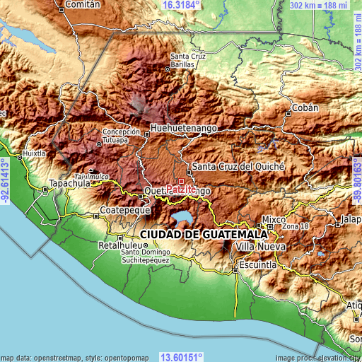
| \ | Map #1 | Topo.Map |
| Scale [m] | 1917..2932 m | × |
| Scale [ft] | 6289..9619 ft | × |
| Average | 2226.6 m = 7305 ft | × |
| Width | 9.44 km = 5.9 mi | 302.1 km = 187.7 mi |
| Height | 9.44 km = 5.9 mi | 302.1 km = 187.7 mi |
| ↑Max Latitude | 15.006711° | 16.3184° |
| Latitude at center | 14.96426° | 14.96426° |
| ↓Min Latitude | 14.921801° | 13.60151° |
| ← Min Longitude | -91.251825° | -92.61413° |
| Longitude center | -91.20788° | -91.20788° |
| →Max Longitude | -91.163935° | -89.80163° |
Nearby cities:
Cities around Patzité sort by population:
• Chichicastenango elevation 2049 m
10.6 km,  102°
102°
• Totonicapán 2499 m
17.5 km,  250°
250°
• Sololá 2126 m
21.5 km,  172°
172°
• Nahualá 2482 m
17.9 km,  221°
221°
• Santa Cruz del Quiché 2023 m
9.8 km,  40°
40°
• Santa María Chiquimula 2085 m
14.9 km,  299°
299°
• Concepción 2072 m
21 km,  162°
162°
• Chinique 1924 m
21.3 km,  66°
66°
• Chiché 2009 m
16.3 km, 72°
• San Antonio Ilotenango 1946 m
10.3 km,  346°
346°
• Santa Lucia La Reforma 1895 m
18.5 km, 350°
• San Pédro Jocopilas 2140 m
15.8 km,  22°
22°
Multilingual:
 En español:
Patzité elevación 2300 m.
 En France:
Patzité élévation 2300 m.
 Auf Deutsch:
Patzité höhe über dem Meeresspiegel ist 2300 m.

Sources and notes:
- [note 1] Map square and city borders are not equal. Map elevation data is calculated only from area inside that square.
- [src 1] Elevation data from geonames database provided with same terms of usage.
- [src 2] The elevation map of Patzité is generated using elevation data from NASA's 3 arcsec (90m) resolution SRTM data.
- [src 3] Base (background) map © OpenStreetMap contributors tiles are generated by Geofabrik and OpenTopoMap.
Copyright & License:
This Patzité Elevation Map is licensed under CC BY-SA. You may reuse any part from this page, if you give a proper credit by linking to this URL:
 More info on terms of use page.