San Martín Jilotepeque elevation
San Martín Jilotepeque (Chimaltenango), Guatemala elevation is 1728 meters and San Martín Jilotepeque elevation in feet is 5669 ft above sea level [src 1]. San Martín Jilotepeque is a seat of a second-order administrative division (feature code) with elevation that is 461 meters (1512 ft) bigger than average city elevation in Guatemala.
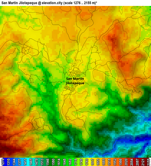
Below is the Elevation map of San Martín Jilotepeque, which displays elevation range with different colors. Scale of the first map is from 1276 to 2155 m (4186 to 7070 ft) with average elevation of 1767.3 meters (=5798 ft) [note 1]
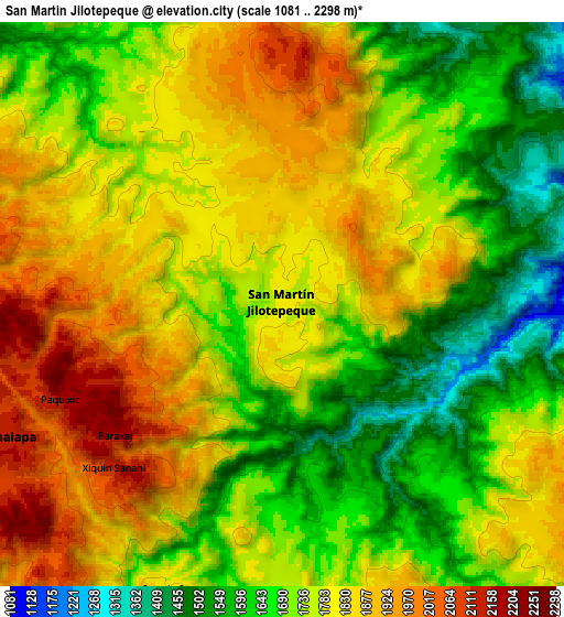
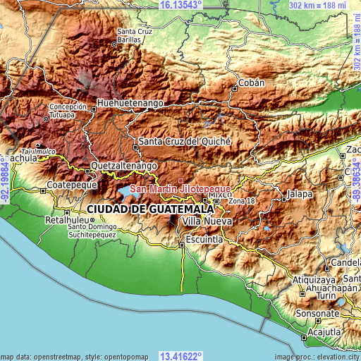
These maps also provides idea of topography and contour of this city, they are displayed at different zoom levels. More info about maps, scale and edge coordinates you can find below images.
| \ | Map #1 | Map #2 | Topo.Map |
| Scale [m] | 1276..2155 m | 1081..2298 m | × |
| Scale [ft] | 4186..7070 ft | 3547..7539 ft | × |
| Average | 1767.3 m = 5798 ft | 1761.3 m = 5779 ft | × |
| Width | 9.45 km = 5.9 mi | 18.9 km = 11.7 mi | 302.3 km = 187.8 mi |
| Height | 9.45 km = 5.9 mi | 18.9 km = 11.7 mi | 302.4 km = 187.9 mi |
| ↑Max Latitude | 14.822567° | 14.865046° | 16.13543° |
| Latitude at center | 14.78008° | 14.78008° | 14.78008° |
| ↓Min Latitude | 14.737585° | 14.695081° | 13.41622° |
| ← Min Longitude | -90.836535° | -90.880481° | -92.19884° |
| Longitude center | -90.79259° | -90.79259° | -90.79259° |
| →Max Longitude | -90.748645° | -90.704699° | -89.38634° |
Nearby cities:
Cities around San Martín Jilotepeque sort by population:
• San Juan Sacatepéquez elevation 1842 m
17.3 km,  113°
113°
• Chimaltenango 1803 m
13.5 km,  192°
192°
• Sumpango 1897 m
16.2 km,  157°
157°
• Comalapa 2115 m
11.1 km,  246°
246°
• San Andrés Itzapa 1858 m
18.4 km,  197°
197°
• El Tejar 1776 m
14.8 km,  179°
179°
• San Pedro Sacatepéquez 2096 m
19.2 km,  122°
122°
• Parramos 1740 m
19.1 km, 183°
• Zaragoza 2083 m
17.9 km,  215°
215°
• Santo Domingo Xenacoj 1805 m
14.9 km,  138°
138°
• Santa Cruz Balanyá 2036 m
17.2 km,  232°
232°
• San José Poaquil 1936 m
13.6 km,  288°
288°
Multilingual:
 En español:
San Martín Jilotepeque elevación 1728 m.
 En France:
San Martín Jilotepeque élévation 1728 m.
 Auf Deutsch:
San Martín Jilotepeque höhe über dem Meeresspiegel ist 1728 m.
 На русском:
San Martín Jilotepeque высота над уровнем моря 1728 м
Sources and notes:
- [note 1] Map square and city borders are not equal. Map elevation data is calculated only from area inside that square.
- [src 1] Elevation data from geonames database provided with same terms of usage.
- [src 2] The elevation map of San Martín Jilotepeque is generated using elevation data from NASA's 3 arcsec (90m) resolution SRTM data.
- [src 3] Base (background) map © OpenStreetMap contributors tiles are generated by Geofabrik and OpenTopoMap.
Copyright & License:
This San Martín Jilotepeque Elevation Map is licensed under CC BY-SA. You may reuse any part from this page, if you give a proper credit by linking to this URL:
 More info on terms of use page.