Chimaltenango elevation
Chimaltenango, Guatemala elevation is 1803 meters and Chimaltenango elevation in feet is 5915 ft above sea level [src 1]. Chimaltenango is a seat of a first-order administrative division (feature code) with elevation that is 536 meters (1759 ft) bigger than average city elevation in Guatemala.
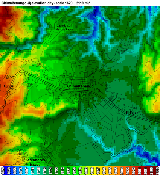
Below is the Elevation map of Chimaltenango, which displays elevation range with different colors. Scale of the first map is from 1620 to 2119 m (5315 to 6952 ft) with average elevation of 1813.1 meters (=5948 ft) [note 1]
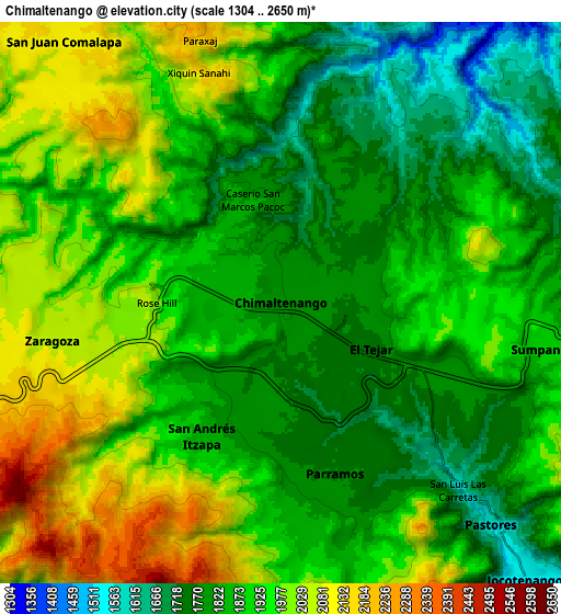
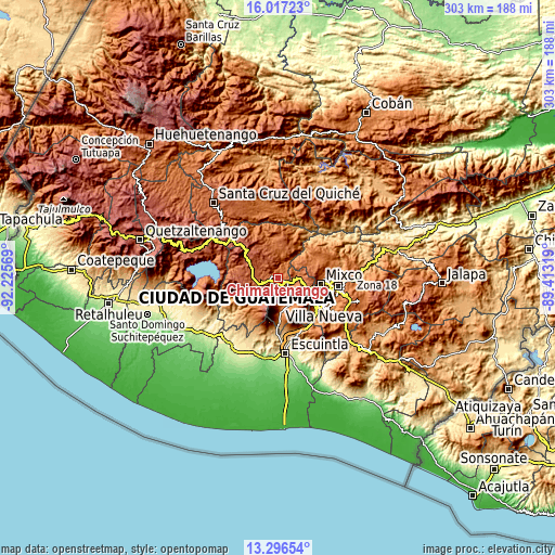
These maps also provides idea of topography and contour of this city, they are displayed at different zoom levels. More info about maps, scale and edge coordinates you can find below images.
| \ | Map #1 | Map #2 | Topo.Map |
| Scale [m] | 1620..2119 m | 1304..2650 m | × |
| Scale [ft] | 5315..6952 ft | 4278..8694 ft | × |
| Average | 1813.1 m = 5948 ft | 1895.4 m = 6219 ft | × |
| Width | 9.45 km = 5.9 mi | 18.91 km = 11.8 mi | 302.5 km = 188 mi |
| Height | 9.45 km = 5.9 mi | 18.91 km = 11.8 mi | 302.5 km = 188 mi |
| ↑Max Latitude | 14.70362° | 14.746122° | 16.01723° |
| Latitude at center | 14.66111° | 14.66111° | 14.66111° |
| ↓Min Latitude | 14.618591° | 14.576065° | 13.29654° |
| ← Min Longitude | -90.863385° | -90.907331° | -92.22569° |
| Longitude center | -90.81944° | -90.81944° | -90.81944° |
| →Max Longitude | -90.775495° | -90.731549° | -89.41319° |
Nearby cities:
Cities around Chimaltenango sort by population:
• Sumpango elevation 1897 m
9.3 km,  100°
100°
• Comalapa 2115 m
11.5 km,  320°
320°
• San Andrés Itzapa 1858 m
5 km,  210°
210°
• Jocotenango 1590 m
12.7 km,  136°
136°
• Patzicía 2129 m
12 km,  254°
254°
• El Tejar 1776 m
3.4 km,  117°
117°
• Pastores 1603 m
10.2 km, 136°
• Parramos 1740 m
6.1 km,  163°
163°
• Zaragoza 2083 m
7.7 km,  260°
260°
• Santo Domingo Xenacoj 1805 m
13 km,  80°
80°
• Santa Cruz Balanyá 2036 m
11 km,  284°
284°
• Santa Catarina Barahona 1556 m
12.7 km, 163°
Multilingual:
 En español:
Chimaltenango elevación 1803 m.
 En France:
Chimaltenango élévation 1803 m.
 Auf Deutsch:
Chimaltenango höhe über dem Meeresspiegel ist 1803 m.

Sources and notes:
- [note 1] Map square and city borders are not equal. Map elevation data is calculated only from area inside that square.
- [src 1] Elevation data from geonames database provided with same terms of usage.
- [src 2] The elevation map of Chimaltenango is generated using elevation data from NASA's 3 arcsec (90m) resolution SRTM data.
- [src 3] Base (background) map © OpenStreetMap contributors tiles are generated by Geofabrik and OpenTopoMap.
Copyright & License:
This Chimaltenango Elevation Map is licensed under CC BY-SA. You may reuse any part from this page, if you give a proper credit by linking to this URL:
 More info on terms of use page.