San José Acatempa elevation
San José Acatempa (Jutiapa), Guatemala elevation is 1346 meters and San José Acatempa elevation in feet is 4416 ft above sea level [src 1]. San José Acatempa is a seat of a second-order administrative division (feature code) with elevation that is 79 meters (259 ft) bigger than average city elevation in Guatemala.
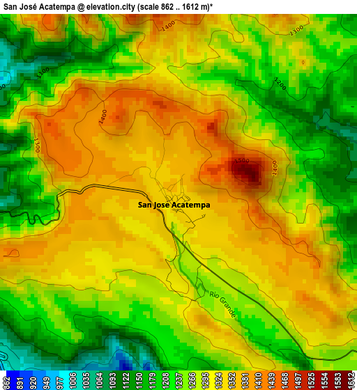
Below is the Elevation map of San José Acatempa, which displays elevation range with different colors. Scale of the first map is from 862 to 1612 m (2828 to 5289 ft) with average elevation of 1282.2 meters (=4207 ft) [note 1]
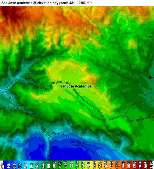
These maps also provides idea of topography and contour of this city, they are displayed at different zoom levels. More info about maps, scale and edge coordinates you can find below images.
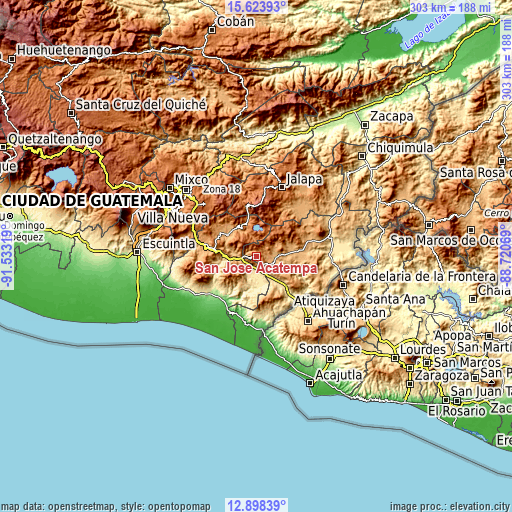
| \ | Map #1 | Map #2 | Topo.Map |
| Scale [m] | 862..1612 m | 481..2163 m | × |
| Scale [ft] | 2828..5289 ft | 1578..7096 ft | × |
| Average | 1282.2 m = 4207 ft | 1185 m = 3888 ft | × |
| Width | 9.47 km = 5.9 mi | 18.94 km = 11.8 mi | 303.1 km = 188.3 mi |
| Height | 9.47 km = 5.9 mi | 18.94 km = 11.8 mi | 303.1 km = 188.3 mi |
| ↑Max Latitude | 14.307866° | 14.350444° | 15.62393° |
| Latitude at center | 14.26528° | 14.26528° | 14.26528° |
| ↓Min Latitude | 14.222686° | 14.180083° | 12.89839° |
| ← Min Longitude | -90.170885° | -90.214831° | -91.53319° |
| Longitude center | -90.12694° | -90.12694° | -90.12694° |
| →Max Longitude | -90.082995° | -90.039049° | -88.72069° |
Nearby cities:
Cities around San José Acatempa sort by population:
• Jutiapa elevation 905 m
25.1 km,  83°
83°
• Cuilapa 902 m
18.6 km,  273°
273°
• Jalpatagua 587 m
18.8 km,  137°
137°
• Oratorio 1034 m
6.7 km,  231°
231°
• Nueva Santa Rosa 1001 m
20.6 km,  308°
308°
• Casillas 1093 m
21.2 km,  323°
323°
• Moyuta 1285 m
25.7 km,  168°
168°
• Santa Rosa de Lima 948 m
22.7 km, 306°
• Santa María Ixhuatán 1285 m
18 km,  242°
242°
• San Rafael Las Flores 1376 m
24.1 km,  346°
346°
• Quesada 974 m
9.4 km,  86°
86°
• San Juan Tecuaco 414 m
25.2 km,  216°
216°
Multilingual:
 En español:
San José Acatempa elevación 1346 m.
 En France:
San José Acatempa élévation 1346 m.
 Auf Deutsch:
San José Acatempa höhe über dem Meeresspiegel ist 1346 m.
 На русском:
San José Acatempa высота над уровнем моря 1346 м
Sources and notes:
- [note 1] Map square and city borders are not equal. Map elevation data is calculated only from area inside that square.
- [src 1] Elevation data from geonames database provided with same terms of usage.
- [src 2] The elevation map of San José Acatempa is generated using elevation data from NASA's 3 arcsec (90m) resolution SRTM data.
- [src 3] Base (background) map © OpenStreetMap contributors tiles are generated by Geofabrik and OpenTopoMap.
Copyright & License:
This San José Acatempa Elevation Map is licensed under CC BY-SA. You may reuse any part from this page, if you give a proper credit by linking to this URL:
 More info on terms of use page.