Nueva Santa Rosa elevation
Nueva Santa Rosa (Santa Rosa), Guatemala elevation is 1001 meters and Nueva Santa Rosa elevation in feet is 3284 ft above sea level [src 1]. Nueva Santa Rosa is a seat of a second-order administrative division (feature code) with elevation that is 266 meters (873 ft) smaller than average city elevation in Guatemala.
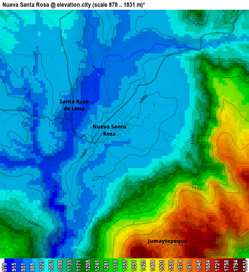
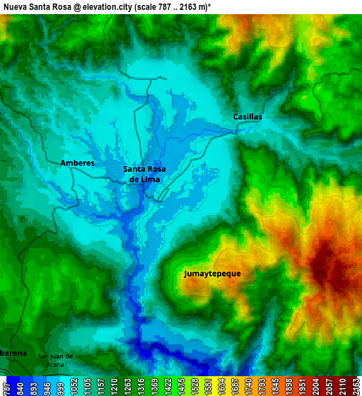
Below is the Elevation map of Nueva Santa Rosa, which displays elevation range with different colors. Scale of the first map is from 878 to 1831 m (2881 to 6007 ft) with average elevation of 1137.4 meters (=3732 ft) [note 1]
These maps also provides idea of topography and contour of this city, they are displayed at different zoom levels. More info about maps, scale and edge coordinates you can find below images.
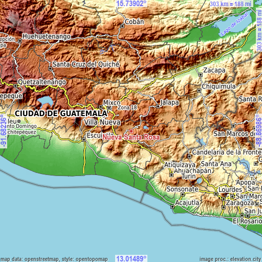
| \ | Map #1 | Map #2 | Topo.Map |
| Scale [m] | 878..1831 m | 787..2163 m | × |
| Scale [ft] | 2881..6007 ft | 2582..7096 ft | × |
| Average | 1137.4 m = 3732 ft | 1245.3 m = 4086 ft | × |
| Width | 9.47 km = 5.9 mi | 18.93 km = 11.8 mi | 302.9 km = 188.2 mi |
| Height | 9.47 km = 5.9 mi | 18.93 km = 11.8 mi | 302.9 km = 188.2 mi |
| ↑Max Latitude | 14.423674° | 14.46623° | 15.73902° |
| Latitude at center | 14.38111° | 14.38111° | 14.38111° |
| ↓Min Latitude | 14.338538° | 14.295957° | 13.01489° |
| ← Min Longitude | -90.320055° | -90.364001° | -91.68236° |
| Longitude center | -90.27611° | -90.27611° | -90.27611° |
| →Max Longitude | -90.232165° | -90.188219° | -88.86986° |
Nearby cities:
Cities around Nueva Santa Rosa sort by population:
• San José Pinula elevation 1778 m
23.5 km,  321°
321°
• Barberena 1186 m
12.3 km,  228°
228°
• Fraijanes 1641 m
20.1 km,  297°
297°
• Cuilapa 902 m
11.9 km,  191°
191°
• Oratorio 1034 m
20.2 km,  147°
147°
• Casillas 1093 m
5.5 km,  39°
39°
• Mataquescuintla 1641 m
19.2 km,  31°
31°
• San José Acatempa 1346 m
20.6 km,  128°
128°
• Santa Cruz Naranjo 1174 m
10.1 km,  274°
274°
• Santa Rosa de Lima 948 m
2.2 km,  290°
290°
• Santa María Ixhuatán 1285 m
21.2 km,  179°
179°
• San Rafael Las Flores 1376 m
14.9 km, 44°
Multilingual:
 En español:
Nueva Santa Rosa elevación 1001 m.
 En France:
Nueva Santa Rosa élévation 1001 m.
 Auf Deutsch:
Nueva Santa Rosa höhe über dem Meeresspiegel ist 1001 m.

Sources and notes:
- [note 1] Map square and city borders are not equal. Map elevation data is calculated only from area inside that square.
- [src 1] Elevation data from geonames database provided with same terms of usage.
- [src 2] The elevation map of Nueva Santa Rosa is generated using elevation data from NASA's 3 arcsec (90m) resolution SRTM data.
- [src 3] Base (background) map © OpenStreetMap contributors tiles are generated by Geofabrik and OpenTopoMap.
Copyright & License:
This Nueva Santa Rosa Elevation Map is licensed under CC BY-SA. You may reuse any part from this page, if you give a proper credit by linking to this URL:
 More info on terms of use page.