Llandrindod Wells elevation
Llandrindod Wells (Wales, Sir Powys), United Kingdom elevation is 216 meters and Llandrindod Wells elevation in feet is 709 ft above sea level [src 1]. Llandrindod Wells is a seat of a second-order administrative division (feature code) with elevation that is 144 meters (472 ft) bigger than average city elevation in United Kingdom.
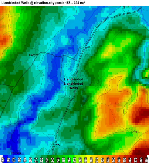
Below is the Elevation map of Llandrindod Wells, which displays elevation range with different colors. Scale of the first map is from 158 to 394 m (518 to 1293 ft) with average elevation of 236 meters (=774 ft) [note 1]
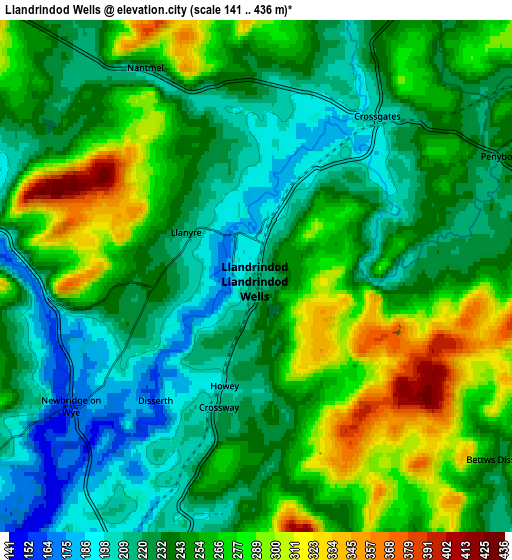
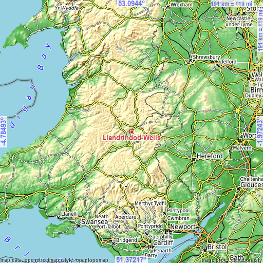
These maps also provides idea of topography and contour of this city, they are displayed at different zoom levels. More info about maps, scale and edge coordinates you can find below images.
| \ | Map #1 | Map #2 | Topo.Map |
| Scale [m] | 158..394 m | 141..436 m | × |
| Scale [ft] | 518..1293 ft | 463..1430 ft | × |
| Average | 236 m = 774 ft | 247 m = 810 ft | × |
| Width | 5.98 km = 3.7 mi | 11.97 km = 7.4 mi | 191.5 km = 119 mi |
| Height | 5.98 km = 3.7 mi | 11.97 km = 7.4 mi | 191.5 km = 119 mi |
| ↑Max Latitude | 52.268541° | 52.295426° | 53.0944° |
| Latitude at center | 52.24164° | 52.24164° | 52.24164° |
| ↓Min Latitude | 52.214723° | 52.187789° | 51.37217° |
| ← Min Longitude | -3.422625° | -3.466571° | -4.78493° |
| Longitude center | -3.37868° | -3.37868° | -3.37868° |
| →Max Longitude | -3.334735° | -3.290789° | -1.97243° |
Nearby cities:
Cities around Llandrindod Wells sort by population:
• Knighton elevation 184 m
25.2 km,  63°
63°
• Llanidloes 169 m
25.6 km,  334°
334°
• Builth Wells 130 m
10.4 km,  189°
189°
• Kington 156 m
24.4 km,  99°
99°
• Presteigne 160 m
25.6 km,  82°
82°
• Rhayader 219 m
11.2 km,  306°
306°
• Talgarth 129 m
29.1 km,  159°
159°
• Mochdre 204 m
26.9 km,  1°
1°
• Hay 97 m
25.6 km,  137°
137°
• Clifford 128 m
24.7 km,  129°
129°
• Whitton 205 m
22.2 km,  73°
73°
• Penybont 226 m
6 km, 62°
Multilingual:
 En español:
Llandrindod Wells elevación 216 m.
 En France:
Llandrindod Wells élévation 216 m.
 Auf Deutsch:
Llandrindod Wells höhe über dem Meeresspiegel ist 216 m.

Sources and notes:
- [note 1] Map square and city borders are not equal. Map elevation data is calculated only from area inside that square.
- [src 1] Elevation data from geonames database provided with same terms of usage.
- [src 2] The elevation map of Llandrindod Wells is generated using elevation data from NASA's 3 arcsec (90m) resolution SRTM data.
- [src 3] Base (background) map © OpenStreetMap contributors tiles are generated by Geofabrik and OpenTopoMap.
Copyright & License:
This Llandrindod Wells Elevation Map is licensed under CC BY-SA. You may reuse any part from this page, if you give a proper credit by linking to this URL:
 More info on terms of use page.