Clifford elevation
Clifford (England, Herefordshire), United Kingdom elevation is 128 meters and Clifford elevation in feet is 420 ft above sea level [src 1]. Clifford is a seat of a third-order administrative division (feature code) with elevation that is 56 meters (184 ft) bigger than average city elevation in United Kingdom.
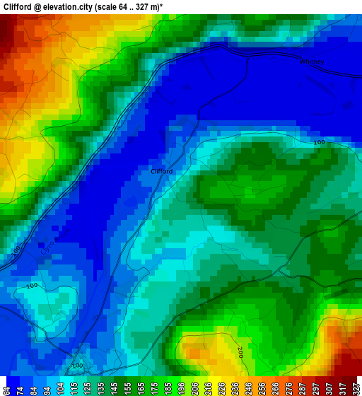
Below is the Elevation map of Clifford, which displays elevation range with different colors. Scale of the first map is from 64 to 327 m (210 to 1073 ft) with average elevation of 135.7 meters (=445 ft) [note 1]
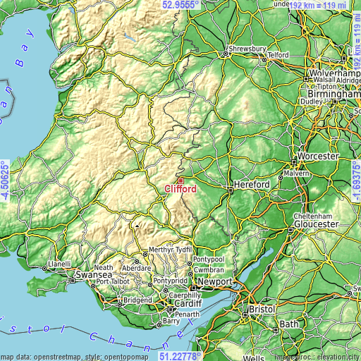
These maps also provides idea of topography and contour of this city, they are displayed at different zoom levels. More info about maps, scale and edge coordinates you can find below images.
| \ | Map #1 | Topo.Map |
| Scale [m] | 64..327 m | × |
| Scale [ft] | 210..1073 ft | × |
| Average | 135.7 m = 445 ft | × |
| Width | 6 km = 3.7 mi | 192.1 km = 119.4 mi |
| Height | 6 km = 3.7 mi | 192.1 km = 119.4 mi |
| ↑Max Latitude | 52.126987° | 52.9555° |
| Latitude at center | 52.1° | 52.1° |
| ↓Min Latitude | 52.072997° | 51.22778° |
| ← Min Longitude | -3.143945° | -4.50625° |
| Longitude center | -3.1° | -3.1° |
| →Max Longitude | -3.056055° | -1.69375° |
Nearby cities:
Cities around Clifford sort by population:
• Kington elevation 156 m
12.6 km,  23°
23°
• Talgarth 129 m
14.7 km,  217°
217°
• Weobley 103 m
16.7 km,  66°
66°
• Dorstone 156 m
7.8 km,  118°
118°
• Bacton 137 m
18 km,  135°
135°
• Bridge Sollers 60 m
16.5 km,  99°
99°
• Llanveynoe 251 m
16.3 km,  155°
155°
• Yazor 194 m
16 km,  83°
83°
• Tyberton 87 m
14.7 km,  114°
114°
• Turnastone 128 m
13.4 km,  129°
129°
• Kinnersley 74 m
10.9 km, 70°
• Hay 97 m
3.8 km,  209°
209°
Multilingual:
 En español:
Clifford elevación 128 m.
 En France:
Clifford élévation 128 m.
 Auf Deutsch:
Clifford höhe über dem Meeresspiegel ist 128 m.

Sources and notes:
- [note 1] Map square and city borders are not equal. Map elevation data is calculated only from area inside that square.
- [src 1] Elevation data from geonames database provided with same terms of usage.
- [src 2] The elevation map of Clifford is generated using elevation data from NASA's 3 arcsec (90m) resolution SRTM data.
- [src 3] Base (background) map © OpenStreetMap contributors tiles are generated by Geofabrik and OpenTopoMap.
Copyright & License:
This Clifford Elevation Map is licensed under CC BY-SA. You may reuse any part from this page, if you give a proper credit by linking to this URL:
 More info on terms of use page.