Bridge Sollers elevation
Bridge Sollers (England, Herefordshire), United Kingdom elevation is 60 meters and Bridge Sollers elevation in feet is 197 ft above sea level [src 1]. Bridge Sollers is a seat of a third-order administrative division (feature code) with elevation that is 12 meters (39 ft) smaller than average city elevation in United Kingdom.
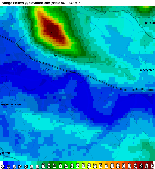
Below is the Elevation map of Bridge Sollers, which displays elevation range with different colors. Scale of the first map is from 54 to 237 m (177 to 778 ft) with average elevation of 83.6 meters (=274 ft) [note 1]
These maps also provides idea of topography and contour of this city, they are displayed at different zoom levels. More info about maps, scale and edge coordinates you can find below images.
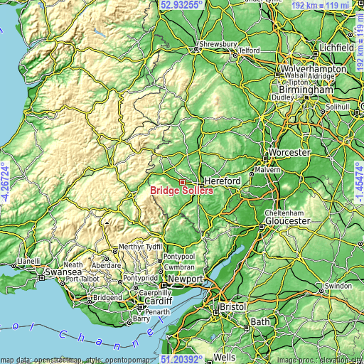
| \ | Map #1 | Topo.Map |
| Scale [m] | 54..237 m | × |
| Scale [ft] | 177..778 ft | × |
| Average | 83.6 m = 274 ft | × |
| Width | 6.01 km = 3.7 mi | 192.2 km = 119.4 mi |
| Height | 6.01 km = 3.7 mi | 192.2 km = 119.4 mi |
| ↑Max Latitude | 52.103601° | 52.93255° |
| Latitude at center | 52.0766° | 52.0766° |
| ↓Min Latitude | 52.049583° | 51.20392° |
| ← Min Longitude | -2.904935° | -4.26724° |
| Longitude center | -2.86099° | -2.86099° |
| →Max Longitude | -2.817045° | -1.45474° |
Nearby cities:
Cities around Bridge Sollers sort by population:
• Hereford elevation 61 m
10.2 km,  102°
102°
• Belmont 63 m
9 km,  114°
114°
• Credenhill 76 m
3.7 km,  78°
78°
• Weobley 103 m
9.3 km,  354°
354°
• Dorstone 156 m
9.6 km,  263°
263°
• Wellington 64 m
10 km,  54°
54°
• Thruxton 103 m
9 km,  160°
160°
• Kinnersley 74 m
8.8 km,  316°
316°
• Turnastone 128 m
8.4 km,  225°
225°
• Kingstone 90 m
6.9 km, 164°
• Yazor 194 m
4.5 km,  355°
355°
• Tyberton 87 m
4.5 km,  220°
220°
Multilingual:
 En español:
Bridge Sollers elevación 60 m.
 En France:
Bridge Sollers élévation 60 m.
 Auf Deutsch:
Bridge Sollers höhe über dem Meeresspiegel ist 60 m.

Sources and notes:
- [note 1] Map square and city borders are not equal. Map elevation data is calculated only from area inside that square.
- [src 1] Elevation data from geonames database provided with same terms of usage.
- [src 2] The elevation map of Bridge Sollers is generated using elevation data from NASA's 3 arcsec (90m) resolution SRTM data.
- [src 3] Base (background) map © OpenStreetMap contributors tiles are generated by Geofabrik and OpenTopoMap.
Copyright & License:
This Bridge Sollers Elevation Map is licensed under CC BY-SA. You may reuse any part from this page, if you give a proper credit by linking to this URL:
 More info on terms of use page.