Thruxton elevation
Thruxton (England, Herefordshire), United Kingdom elevation is 103 meters and Thruxton elevation in feet is 338 ft above sea level [src 1]. Thruxton is a seat of a third-order administrative division (feature code) with elevation that is 31 meters (102 ft) bigger than average city elevation in United Kingdom.
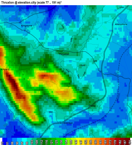
Below is the Elevation map of Thruxton, which displays elevation range with different colors. Scale of the first map is from 77 to 191 m (253 to 627 ft) with average elevation of 104 meters (=341 ft) [note 1]
These maps also provides idea of topography and contour of this city, they are displayed at different zoom levels. More info about maps, scale and edge coordinates you can find below images.
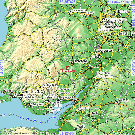
| \ | Map #1 | Topo.Map |
| Scale [m] | 77..191 m | × |
| Scale [ft] | 253..627 ft | × |
| Average | 104 m = 341 ft | × |
| Width | 6.02 km = 3.7 mi | 192.5 km = 119.6 mi |
| Height | 6.02 km = 3.7 mi | 192.5 km = 119.6 mi |
| ↑Max Latitude | 52.027047° | 52.85742° |
| Latitude at center | 52° | 52° |
| ↓Min Latitude | 51.972936° | 51.12583° |
| ← Min Longitude | -2.860615° | -4.22292° |
| Longitude center | -2.81667° | -2.81667° |
| →Max Longitude | -2.772725° | -1.41042° |
Nearby cities:
Cities around Thruxton sort by population:
• Hereford elevation 61 m
9.4 km,  47°
47°
• Belmont 63 m
7 km, 47°
• Credenhill 76 m
9.3 km,  3°
3°
• Ewyas Harold 77 m
7.4 km,  225°
225°
• Bridge Sollers 60 m
9 km,  340°
340°
• Lower Bullingham 56 m
8.8 km,  65°
65°
• Tyberton 87 m
7.8 km,  310°
310°
• Bacton 137 m
7.1 km,  254°
254°
• Much Birch 163 m
7.1 km,  116°
116°
• Abbey Dore 161 m
6.8 km,  236°
236°
• Callow 77 m
6 km, 71°
• Kingstone 90 m
2.2 km,  328°
328°
Multilingual:
 En español:
Thruxton elevación 103 m.
 En France:
Thruxton élévation 103 m.
 Auf Deutsch:
Thruxton höhe über dem Meeresspiegel ist 103 m.

Sources and notes:
- [note 1] Map square and city borders are not equal. Map elevation data is calculated only from area inside that square.
- [src 1] Elevation data from geonames database provided with same terms of usage.
- [src 2] The elevation map of Thruxton is generated using elevation data from NASA's 3 arcsec (90m) resolution SRTM data.
- [src 3] Base (background) map © OpenStreetMap contributors tiles are generated by Geofabrik and OpenTopoMap.
Copyright & License:
This Thruxton Elevation Map is licensed under CC BY-SA. You may reuse any part from this page, if you give a proper credit by linking to this URL:
 More info on terms of use page.