Weobley elevation
Weobley (England, Herefordshire), United Kingdom elevation is 103 meters and Weobley elevation in feet is 338 ft above sea level [src 1]. Weobley is a populated place (feature code) with elevation that is 31 meters (102 ft) bigger than average city elevation in United Kingdom.
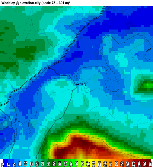
Below is the Elevation map of Weobley, which displays elevation range with different colors. Scale of the first map is from 78 to 301 m (256 to 988 ft) with average elevation of 124.4 meters (=408 ft) [note 1]
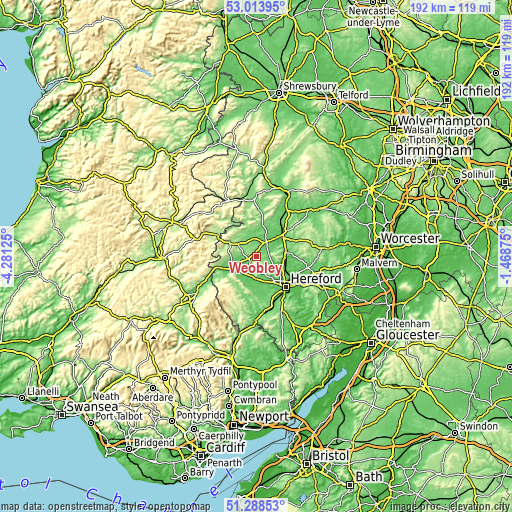
These maps also provides idea of topography and contour of this city, they are displayed at different zoom levels. More info about maps, scale and edge coordinates you can find below images.
| \ | Map #1 | Topo.Map |
| Scale [m] | 78..301 m | × |
| Scale [ft] | 256..988 ft | × |
| Average | 124.4 m = 408 ft | × |
| Width | 6 km = 3.7 mi | 191.8 km = 119.2 mi |
| Height | 6 km = 3.7 mi | 191.8 km = 119.2 mi |
| ↑Max Latitude | 52.186551° | 53.01395° |
| Latitude at center | 52.1596° | 52.1596° |
| ↓Min Latitude | 52.132633° | 51.28853° |
| ← Min Longitude | -2.918945° | -4.28125° |
| Longitude center | -2.875° | -2.875° |
| →Max Longitude | -2.831055° | -1.46875° |
Nearby cities:
Cities around Weobley sort by population:
• Leominster elevation 89 m
11.5 km,  50°
50°
• Kington 156 m
11.4 km,  295°
295°
• Credenhill 76 m
9.6 km,  151°
151°
• Kingsland 89 m
10.7 km,  22°
22°
• Bodenham 60 m
13.1 km,  94°
94°
• Tyberton 87 m
12.8 km,  188°
188°
• Hope under Dinmore 77 m
11.1 km,  76°
76°
• Wellington 64 m
9.7 km,  110°
110°
• Bridge Sollers 60 m
9.3 km,  174°
174°
• Dinmore 153 m
8.6 km,  97°
97°
• Kinnersley 74 m
5.9 km,  240°
240°
• Yazor 194 m
4.8 km, 173°
Multilingual:
 En español:
Weobley elevación 103 m.
 En France:
Weobley élévation 103 m.


Sources and notes:
- [note 1] Map square and city borders are not equal. Map elevation data is calculated only from area inside that square.
- [src 1] Elevation data from geonames database provided with same terms of usage.
- [src 2] The elevation map of Weobley is generated using elevation data from NASA's 3 arcsec (90m) resolution SRTM data.
- [src 3] Base (background) map © OpenStreetMap contributors tiles are generated by Geofabrik and OpenTopoMap.
Copyright & License:
This Weobley Elevation Map is licensed under CC BY-SA. You may reuse any part from this page, if you give a proper credit by linking to this URL:
 More info on terms of use page.