Dinmore elevation
Dinmore (England, Herefordshire), United Kingdom elevation is 153 meters and Dinmore elevation in feet is 502 ft above sea level [src 1]. Dinmore is a seat of a third-order administrative division (feature code) with elevation that is 81 meters (266 ft) bigger than average city elevation in United Kingdom.
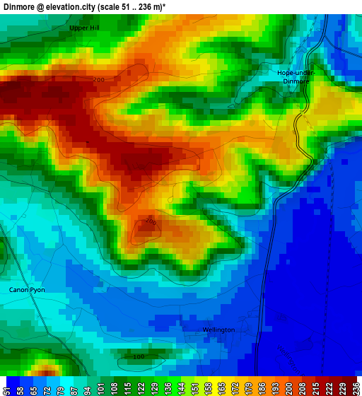
Below is the Elevation map of Dinmore, which displays elevation range with different colors. Scale of the first map is from 51 to 236 m (167 to 774 ft) with average elevation of 118 meters (=387 ft) [note 1]
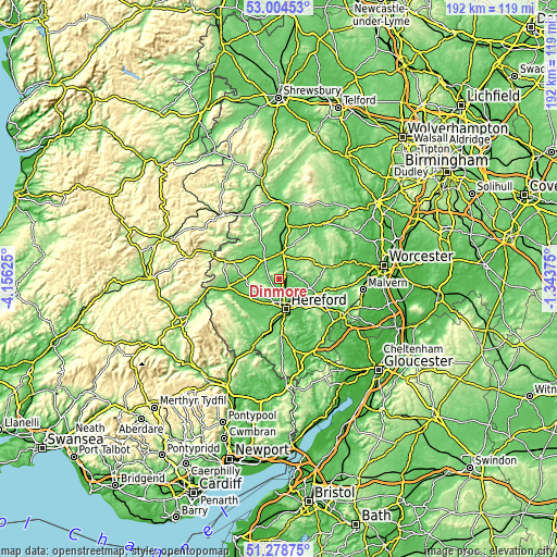
These maps also provides idea of topography and contour of this city, they are displayed at different zoom levels. More info about maps, scale and edge coordinates you can find below images.
| \ | Map #1 | Topo.Map |
| Scale [m] | 51..236 m | × |
| Scale [ft] | 167..774 ft | × |
| Average | 118 m = 387 ft | × |
| Width | 6 km = 3.7 mi | 191.9 km = 119.2 mi |
| Height | 6 km = 3.7 mi | 191.9 km = 119.2 mi |
| ↑Max Latitude | 52.176957° | 53.00453° |
| Latitude at center | 52.15° | 52.15° |
| ↓Min Latitude | 52.123027° | 51.27875° |
| ← Min Longitude | -2.793945° | -4.15625° |
| Longitude center | -2.75° | -2.75° |
| →Max Longitude | -2.706055° | -1.34375° |
Nearby cities:
Cities around Dinmore sort by population:
• Hereford elevation 61 m
10.6 km,  166°
166°
• Leominster 89 m
8.4 km,  2°
2°
• Credenhill 76 m
8.4 km,  208°
208°
• Weobley 103 m
8.6 km,  277°
277°
• Ocle Pychard 80 m
10.9 km,  109°
109°
• Withington 72 m
9.7 km,  124°
124°
• Yazor 194 m
8.8 km,  245°
245°
• Humber 129 m
7.9 km,  45°
45°
• Sutton 52 m
7.2 km,  140°
140°
• Bodenham 60 m
4.5 km,  90°
90°
• Hope under Dinmore 77 m
4.3 km,  31°
31°
• Wellington 64 m
2.4 km, 166°
Multilingual:
 En español:
Dinmore elevación 153 m.
 En France:
Dinmore élévation 153 m.


Sources and notes:
- [note 1] Map square and city borders are not equal. Map elevation data is calculated only from area inside that square.
- [src 1] Elevation data from geonames database provided with same terms of usage.
- [src 2] The elevation map of Dinmore is generated using elevation data from NASA's 3 arcsec (90m) resolution SRTM data.
- [src 3] Base (background) map © OpenStreetMap contributors tiles are generated by Geofabrik and OpenTopoMap.
Copyright & License:
This Dinmore Elevation Map is licensed under CC BY-SA. You may reuse any part from this page, if you give a proper credit by linking to this URL:
 More info on terms of use page.