Leominster elevation
Leominster (England, Herefordshire), United Kingdom elevation is 89 meters and Leominster elevation in feet is 292 ft above sea level [src 1]. Leominster is a populated place (feature code) with elevation that is 17 meters (56 ft) bigger than average city elevation in United Kingdom.
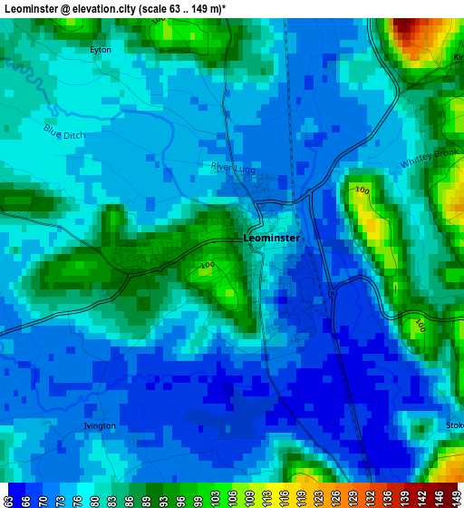
Below is the Elevation map of Leominster, which displays elevation range with different colors. Scale of the first map is from 63 to 149 m (207 to 489 ft) with average elevation of 79.2 meters (=260 ft) [note 1]
These maps also provides idea of topography and contour of this city, they are displayed at different zoom levels. More info about maps, scale and edge coordinates you can find below images.
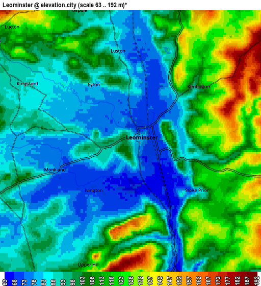
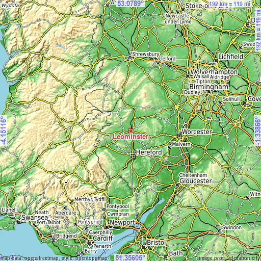
| \ | Map #1 | Map #2 | Topo.Map |
| Scale [m] | 63..149 m | 63..192 m | × |
| Scale [ft] | 207..489 ft | 207..630 ft | × |
| Average | 79.2 m = 260 ft | 101.5 m = 333 ft | × |
| Width | 5.99 km = 3.7 mi | 11.97 km = 7.4 mi | 191.6 km = 119.1 mi |
| Height | 5.99 km = 3.7 mi | 11.97 km = 7.4 mi | 191.5 km = 119 mi |
| ↑Max Latitude | 52.252741° | 52.279635° | 53.0789° |
| Latitude at center | 52.22583° | 52.22583° | 52.22583° |
| ↓Min Latitude | 52.198903° | 52.17196° | 51.35605° |
| ← Min Longitude | -2.788855° | -2.832801° | -4.15116° |
| Longitude center | -2.74491° | -2.74491° | -2.74491° |
| →Max Longitude | -2.700965° | -2.657019° | -1.33866° |
Nearby cities:
Cities around Leominster sort by population:
• Weobley elevation 103 m
11.5 km,  230°
230°
• Wigmore 133 m
12.5 km,  322°
322°
• Orleton 92 m
8.3 km,  357°
357°
• Kingsland 89 m
5.5 km,  298°
298°
• Wacton 173 m
12.2 km,  94°
94°
• Wellington 64 m
10.7 km,  178°
178°
• Bodenham 60 m
9.4 km,  153°
153°
• Dinmore 153 m
8.4 km, 182°
• Humber 129 m
6.1 km,  118°
118°
• Hope under Dinmore 77 m
5.1 km,  157°
157°
• Kimbolton 101 m
4.1 km,  48°
48°
• Eyton 100 m
2.7 km,  352°
352°
Multilingual:
 En español:
Leominster elevación 89 m.
 En France:
Leominster élévation 89 m.
 Auf Deutsch:
Leominster höhe über dem Meeresspiegel ist 89 m.

Sources and notes:
- [note 1] Map square and city borders are not equal. Map elevation data is calculated only from area inside that square.
- [src 1] Elevation data from geonames database provided with same terms of usage.
- [src 2] The elevation map of Leominster is generated using elevation data from NASA's 3 arcsec (90m) resolution SRTM data.
- [src 3] Base (background) map © OpenStreetMap contributors tiles are generated by Geofabrik and OpenTopoMap.
Copyright & License:
This Leominster Elevation Map is licensed under CC BY-SA. You may reuse any part from this page, if you give a proper credit by linking to this URL:
 More info on terms of use page.