Mochdre elevation
Mochdre (Wales, Sir Powys), United Kingdom elevation is 204 meters and Mochdre elevation in feet is 669 ft above sea level [src 1]. Mochdre is a seat of a third-order administrative division (feature code) with elevation that is 132 meters (433 ft) bigger than average city elevation in United Kingdom.
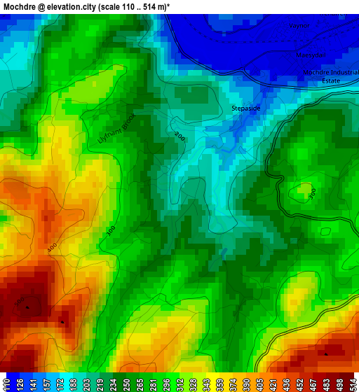
Below is the Elevation map of Mochdre, which displays elevation range with different colors. Scale of the first map is from 110 to 514 m (361 to 1686 ft) with average elevation of 275.1 meters (=903 ft) [note 1]
These maps also provides idea of topography and contour of this city, they are displayed at different zoom levels. More info about maps, scale and edge coordinates you can find below images.
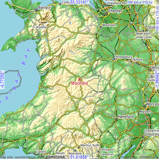
| \ | Map #1 | Topo.Map |
| Scale [m] | 110..514 m | × |
| Scale [ft] | 361..1686 ft | × |
| Average | 275.1 m = 903 ft | × |
| Width | 5.95 km = 3.7 mi | 190.4 km = 118.3 mi |
| Height | 5.95 km = 3.7 mi | 190.4 km = 118.3 mi |
| ↑Max Latitude | 52.510084° | 53.33141° |
| Latitude at center | 52.48333° | 52.48333° |
| ↓Min Latitude | 52.45656° | 51.61858° |
| ← Min Longitude | -3.410615° | -4.77292° |
| Longitude center | -3.36667° | -3.36667° |
| →Max Longitude | -3.322725° | -1.96042° |
Nearby cities:
Cities around Mochdre sort by population:
• Newtown elevation 111 m
5.8 km,  50°
50°
• Welshpool 84 m
24.6 km,  37°
37°
• Llandrindod Wells 216 m
26.9 km,  181°
181°
• Knighton 184 m
26.7 km,  125°
125°
• Llanidloes 169 m
12.3 km,  252°
252°
• Bishop's Castle 200 m
24.7 km,  87°
87°
• Rhayader 219 m
22.5 km,  205°
205°
• Acton 254 m
24 km,  98°
98°
• Llanfair Caereinion 138 m
18.5 km,  8°
8°
• Lydham 182 m
26.4 km,  82°
82°
• Penybont 226 m
24.5 km,  169°
169°
• Mainstone 385 m
19.2 km, 90°
Multilingual:
 En español:
Mochdre elevación 204 m.
 En France:
Mochdre élévation 204 m.


Sources and notes:
- [note 1] Map square and city borders are not equal. Map elevation data is calculated only from area inside that square.
- [src 1] Elevation data from geonames database provided with same terms of usage.
- [src 2] The elevation map of Mochdre is generated using elevation data from NASA's 3 arcsec (90m) resolution SRTM data.
- [src 3] Base (background) map © OpenStreetMap contributors tiles are generated by Geofabrik and OpenTopoMap.
Copyright & License:
This Mochdre Elevation Map is licensed under CC BY-SA. You may reuse any part from this page, if you give a proper credit by linking to this URL:
 More info on terms of use page.