Knighton elevation
Knighton (Wales, Sir Powys), United Kingdom elevation is 184 meters and Knighton elevation in feet is 604 ft above sea level [src 1]. Knighton is a populated place (feature code) with elevation that is 112 meters (367 ft) bigger than average city elevation in United Kingdom.
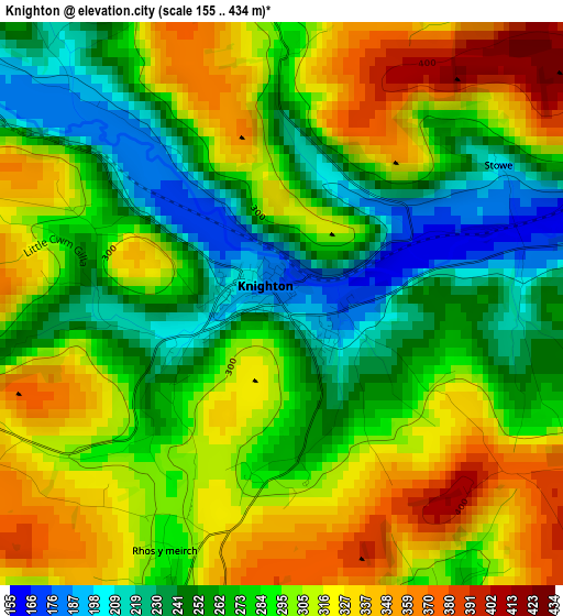
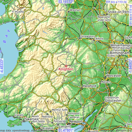
Below is the Elevation map of Knighton, which displays elevation range with different colors. Scale of the first map is from 155 to 434 m (509 to 1424 ft) with average elevation of 288.1 meters (=945 ft) [note 1]
These maps also provides idea of topography and contour of this city, they are displayed at different zoom levels. More info about maps, scale and edge coordinates you can find below images.
| \ | Map #1 | Topo.Map |
| Scale [m] | 155..434 m | × |
| Scale [ft] | 509..1424 ft | × |
| Average | 288.1 m = 945 ft | × |
| Width | 5.97 km = 3.7 mi | 191.1 km = 118.7 mi |
| Height | 5.97 km = 3.7 mi | 191 km = 118.7 mi |
| ↑Max Latitude | 52.36935° | 53.19332° |
| Latitude at center | 52.34251° | 52.34251° |
| ↓Min Latitude | 52.315654° | 51.47501° |
| ← Min Longitude | -3.091025° | -4.45333° |
| Longitude center | -3.04708° | -3.04708° |
| →Max Longitude | -3.003135° | -1.64083° |
Nearby cities:
Cities around Knighton sort by population:
• Kington elevation 156 m
15.5 km,  174°
174°
• Presteigne 160 m
8.3 km,  160°
160°
• Acton 254 m
12.1 km,  9°
9°
• Wigmore 133 m
13.2 km,  103°
103°
• Bucknell 148 m
6.8 km,  73°
73°
• Elton 142 m
16.8 km,  93°
93°
• Mainstone 385 m
15.8 km,  351°
351°
• Burrington 163 m
15.7 km, 86°
• Downton 211 m
14.8 km,  79°
79°
• Kinsham 198 m
10.2 km,  130°
130°
• Lingen 152 m
9.1 km,  121°
121°
• Whitton 205 m
4.9 km,  195°
195°
Multilingual:
 En español:
Knighton elevación 184 m.
 En France:
Knighton élévation 184 m.
 Auf Deutsch:
Knighton höhe über dem Meeresspiegel ist 184 m.

Sources and notes:
- [note 1] Map square and city borders are not equal. Map elevation data is calculated only from area inside that square.
- [src 1] Elevation data from geonames database provided with same terms of usage.
- [src 2] The elevation map of Knighton is generated using elevation data from NASA's 3 arcsec (90m) resolution SRTM data.
- [src 3] Base (background) map © OpenStreetMap contributors tiles are generated by Geofabrik and OpenTopoMap.
Copyright & License:
This Knighton Elevation Map is licensed under CC BY-SA. You may reuse any part from this page, if you give a proper credit by linking to this URL:
 More info on terms of use page.