Bais elevation
Bais (Pays de la Loire, Mayenne), France elevation is 186 meters and Bais elevation in feet is 610 ft above sea level [src 1]. Bais is a populated place (feature code) with elevation that is 12 meters (39 ft) bigger than average city elevation in France.
Below is the Elevation map of Bais, which displays elevation range with different colors. Scale of the first map is from 151 to 348 m (495 to 1142 ft) with average elevation of 232.9 meters (=764 ft) [note 1]
These maps also provides idea of topography and contour of this city, they are displayed at different zoom levels. More info about maps, scale and edge coordinates you can find below images.
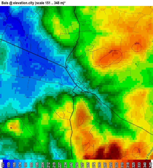
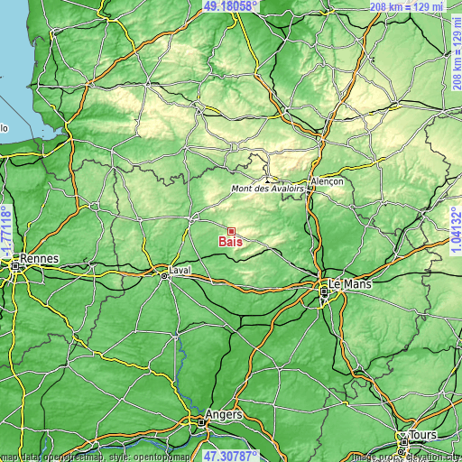
| \ | Map #1 | Topo.Map |
| Scale [m] | 151..348 m | × |
| Scale [ft] | 495..1142 ft | × |
| Average | 232.9 m = 764 ft | × |
| Width | 6.51 km = 4 mi | 208.2 km = 129.4 mi |
| Height | 6.51 km = 4 mi | 208.2 km = 129.4 mi |
| ↑Max Latitude | 48.282052° | 49.18058° |
| Latitude at center | 48.2528° | 48.2528° |
| ↓Min Latitude | 48.223531° | 47.30787° |
| ← Min Longitude | -0.408875° | -1.77118° |
| Longitude center | -0.36493° | -0.36493° |
| →Max Longitude | -0.320985° | 1.04132° |
Nearby cities:
Cities around Bais sort by population:
• Mayenne elevation 123 m
19.2 km,  286°
286°
• Évron 109 m
11 km,  193°
193°
• Villaines-la-Juhel 185 m
12 km,  32°
32°
• Sillé-le-Guillaume 161 m
19.3 km,  113°
113°
• Montsûrs 75 m
19.1 km,  227°
227°
• Aron 128 m
15.3 km, 289°
• Javron-les-Chapelles 180 m
18.5 km,  6°
6°
• Commer 134 m
18.8 km,  263°
263°
• Saint-Baudelle 122 m
20.4 km,  278°
278°
• Sainte-Suzanne 150 m
17.2 km,  177°
177°
• Courcité 181 m
10.4 km,  55°
55°
• Moulay 117 m
19.5 km, 276°
Multilingual:
 En español:
Bais elevación 186 m.
 En France:
Bais élévation 186 m.


Sources and notes:
- [note 1] Map square and city borders are not equal. Map elevation data is calculated only from area inside that square.
- [src 1] Elevation data from geonames database provided with same terms of usage.
- [src 2] The elevation map of Bais is generated using elevation data from NASA's 3 arcsec (90m) resolution SRTM data.
- [src 3] Base (background) map © OpenStreetMap contributors tiles are generated by Geofabrik and OpenTopoMap.
Copyright & License:
This Bais Elevation Map is licensed under CC BY-SA. You may reuse any part from this page, if you give a proper credit by linking to this URL:
 More info on terms of use page.