Mayenne elevation
Mayenne (Pays de la Loire), France elevation is 123 meters and Mayenne elevation in feet is 404 ft above sea level [src 1]. Mayenne is a seat of a third-order administrative division (feature code) with elevation that is 51 meters (167 ft) smaller than average city elevation in France.
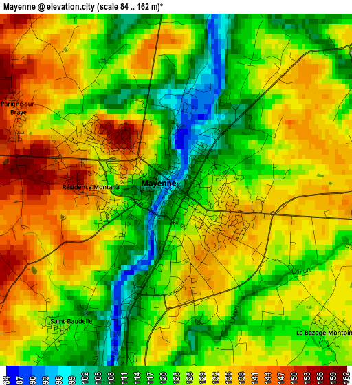
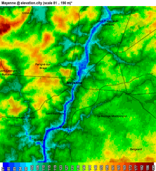
Below is the Elevation map of Mayenne, which displays elevation range with different colors. Scale of the first map is from 84 to 162 m (276 to 531 ft) with average elevation of 126.2 meters (=414 ft) [note 1]
These maps also provides idea of topography and contour of this city, they are displayed at different zoom levels. More info about maps, scale and edge coordinates you can find below images.
| \ | Map #1 | Map #2 | Topo.Map |
| Scale [m] | 84..162 m | 81..190 m | × |
| Scale [ft] | 276..531 ft | 266..623 ft | × |
| Average | 126.2 m = 414 ft | 128.9 m = 423 ft | × |
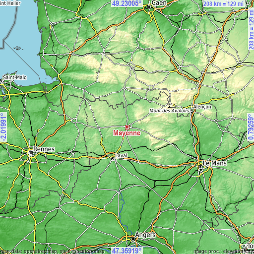
| Width | 6.5 km = 4 mi | 13 km = 8.1 mi | 208 km = 129.2 mi |
| Height | 6.5 km = 4 mi | 13 km = 8.1 mi | 208 km = 129.2 mi |
| ↑Max Latitude | 48.332414° | 48.36162° | 49.23005° |
| Latitude at center | 48.30319° | 48.30319° | 48.30319° |
| ↓Min Latitude | 48.27395° | 48.244693° | 47.35919° |
| ← Min Longitude | -0.657605° | -0.701551° | -2.01991° |
| Longitude center | -0.61366° | -0.61366° | -0.61366° |
| →Max Longitude | -0.569715° | -0.525769° | 0.79259° |
Nearby cities:
Cities around Mayenne sort by population:
• Gorron elevation 163 m
19 km,  309°
309°
• Ambrières-les-Vallées 135 m
10.9 km,  352°
352°
• Lassay-les-Châteaux 197 m
17.3 km,  29°
29°
• Andouillé 85 m
18.9 km,  221°
221°
• Saint-Denis-de-Gastines 230 m
18.6 km,  283°
283°
• Aron 128 m
4 km,  98°
98°
• Saint-Georges-Buttavent 152 m
6 km, 277°
• Martigné-sur-Mayenne 162 m
12.1 km,  198°
198°
• Commer 134 m
7.8 km,  181°
181°
• Oisseau 156 m
7.2 km,  323°
323°
• Saint-Baudelle 122 m
3 km, 215°
• Moulay 117 m
3.6 km, 196°
Multilingual:
 En español:
Mayenne elevación 123 m.
 En France:
Mayenne élévation 123 m.


Sources and notes:
- [note 1] Map square and city borders are not equal. Map elevation data is calculated only from area inside that square.
- [src 1] Elevation data from geonames database provided with same terms of usage.
- [src 2] The elevation map of Mayenne is generated using elevation data from NASA's 3 arcsec (90m) resolution SRTM data.
- [src 3] Base (background) map © OpenStreetMap contributors tiles are generated by Geofabrik and OpenTopoMap.
Copyright & License:
This Mayenne Elevation Map is licensed under CC BY-SA. You may reuse any part from this page, if you give a proper credit by linking to this URL:
 More info on terms of use page.