Le Lardin-Saint-Lazare elevation
Le Lardin-Saint-Lazare (Nouvelle-Aquitaine, Dordogne), France elevation is 104 meters and Le Lardin-Saint-Lazare elevation in feet is 341 ft above sea level [src 1]. Le Lardin-Saint-Lazare is a populated place (feature code) with elevation that is 70 meters (230 ft) smaller than average city elevation in France.
Below is the Elevation map of Le Lardin-Saint-Lazare, which displays elevation range with different colors. Scale of the first map is from 77 to 265 m (253 to 869 ft) with average elevation of 167 meters (=548 ft) [note 1]
These maps also provides idea of topography and contour of this city, they are displayed at different zoom levels. More info about maps, scale and edge coordinates you can find below images.
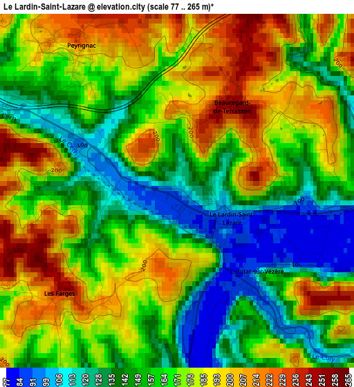
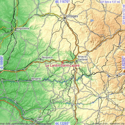
| \ | Map #1 | Topo.Map |
| Scale [m] | 77..265 m | × |
| Scale [ft] | 253..869 ft | × |
| Average | 167 m = 548 ft | × |
| Width | 6.89 km = 4.3 mi | 220.6 km = 137.1 mi |
| Height | 6.89 km = 4.3 mi | 220.6 km = 137.1 mi |
| ↑Max Latitude | 45.164323° | 46.11676° |
| Latitude at center | 45.13333° | 45.13333° |
| ↓Min Latitude | 45.10232° | 44.13265° |
| ← Min Longitude | 1.172725° | -0.18958° |
| Longitude center | 1.21667° | 1.21667° |
| →Max Longitude | 1.260615° | 2.62292° |
Nearby cities:
Cities around Le Lardin-Saint-Lazare sort by population:
• Terrasson-Lavilledieu elevation 87 m
6.7 km,  93°
93°
• Saint-Pantaléon-de-Larche 99 m
18 km, 87°
• Objat 126 m
20.8 km,  46°
46°
• Montignac 80 m
8.8 km,  209°
209°
• Varetz 103 m
19.5 km,  69°
69°
• Cublac 111 m
7.1 km,  79°
79°
• Larche 117 m
15.7 km,  95°
95°
• Saint-Viance 105 m
20.7 km,  63°
63°
• Mansac 195 m
13.6 km, 73°
• Thenon 260 m
11.4 km,  273°
273°
• Hautefort 204 m
15 km,  339°
339°
• Salignac-Eyvigues 290 m
19.6 km,  154°
154°
Multilingual:
 En español:
Le Lardin-Saint-Lazare elevación 104 m.
 En France:
Le Lardin-Saint-Lazare élévation 104 m.
 Auf Deutsch:
Le Lardin-Saint-Lazare höhe über dem Meeresspiegel ist 104 m.
 На русском:
Ле-Ларден-Сен-Лазар высота над уровнем моря 104 м
Sources and notes:
- [note 1] Map square and city borders are not equal. Map elevation data is calculated only from area inside that square.
- [src 1] Elevation data from geonames database provided with same terms of usage.
- [src 2] The elevation map of Le Lardin-Saint-Lazare is generated using elevation data from NASA's 3 arcsec (90m) resolution SRTM data.
- [src 3] Base (background) map © OpenStreetMap contributors tiles are generated by Geofabrik and OpenTopoMap.
Copyright & License:
This Le Lardin-Saint-Lazare Elevation Map is licensed under CC BY-SA. You may reuse any part from this page, if you give a proper credit by linking to this URL:
 More info on terms of use page.