Varetz elevation
Varetz (Nouvelle-Aquitaine, Département de la Corrèze), France elevation is 103 meters and Varetz elevation in feet is 338 ft above sea level [src 1]. Varetz is a populated place (feature code) with elevation that is 71 meters (233 ft) smaller than average city elevation in France.
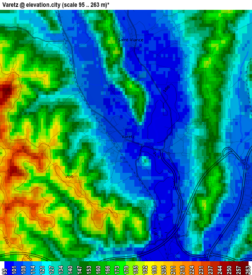
Below is the Elevation map of Varetz, which displays elevation range with different colors. Scale of the first map is from 95 to 263 m (312 to 863 ft) with average elevation of 139.9 meters (=459 ft) [note 1]
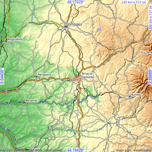
These maps also provides idea of topography and contour of this city, they are displayed at different zoom levels. More info about maps, scale and edge coordinates you can find below images.
| \ | Map #1 | Topo.Map |
| Scale [m] | 95..263 m | × |
| Scale [ft] | 312..863 ft | × |
| Average | 139.9 m = 459 ft | × |
| Width | 6.89 km = 4.3 mi | 220.4 km = 136.9 mi |
| Height | 6.89 km = 4.3 mi | 220.4 km = 136.9 mi |
| ↑Max Latitude | 45.22488° | 46.17629° |
| Latitude at center | 45.19392° | 45.19392° |
| ↓Min Latitude | 45.162943° | 44.19429° |
| ← Min Longitude | 1.406685° | 0.04438° |
| Longitude center | 1.45063° | 1.45063° |
| →Max Longitude | 1.494575° | 2.85688° |
Nearby cities:
Cities around Varetz sort by population:
• Brive-la-Gaillarde elevation 111 m
7.6 km,  121°
121°
• Malemort-sur-Corrèze 116 m
9.2 km,  106°
106°
• Saint-Pantaléon-de-Larche 99 m
5.9 km,  183°
183°
• Allassac 170 m
7.4 km,  15°
15°
• Objat 126 m
8.4 km,  336°
336°
• Ussac 207 m
4.9 km,  90°
90°
• Donzenac 210 m
6.8 km,  57°
57°
• Sainte-Féréole 384 m
11.1 km,  69°
69°
• Larche 117 m
8.6 km,  198°
198°
• Saint-Viance 105 m
2.6 km,  3°
3°
• Voutezac 254 m
11 km,  354°
354°
• Mansac 195 m
6 km,  241°
241°
Multilingual:
 En español:
Varetz elevación 103 m.
 En France:
Varetz élévation 103 m.


Sources and notes:
- [note 1] Map square and city borders are not equal. Map elevation data is calculated only from area inside that square.
- [src 1] Elevation data from geonames database provided with same terms of usage.
- [src 2] The elevation map of Varetz is generated using elevation data from NASA's 3 arcsec (90m) resolution SRTM data.
- [src 3] Base (background) map © OpenStreetMap contributors tiles are generated by Geofabrik and OpenTopoMap.
Copyright & License:
This Varetz Elevation Map is licensed under CC BY-SA. You may reuse any part from this page, if you give a proper credit by linking to this URL:
 More info on terms of use page.