Saint-Pantaléon-de-Larche elevation
Saint-Pantaléon-de-Larche (Nouvelle-Aquitaine, Département de la Corrèze), France elevation is 99 meters and Saint-Pantaléon-de-Larche elevation in feet is 325 ft above sea level [src 1]. Saint-Pantaléon-de-Larche is a populated place (feature code) with elevation that is 75 meters (246 ft) smaller than average city elevation in France.
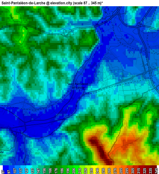
Below is the Elevation map of Saint-Pantaléon-de-Larche, which displays elevation range with different colors. Scale of the first map is from 87 to 345 m (285 to 1132 ft) with average elevation of 147.5 meters (=484 ft) [note 1]
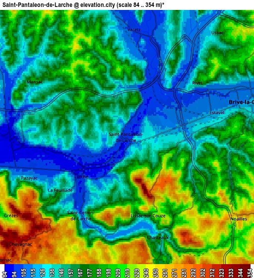
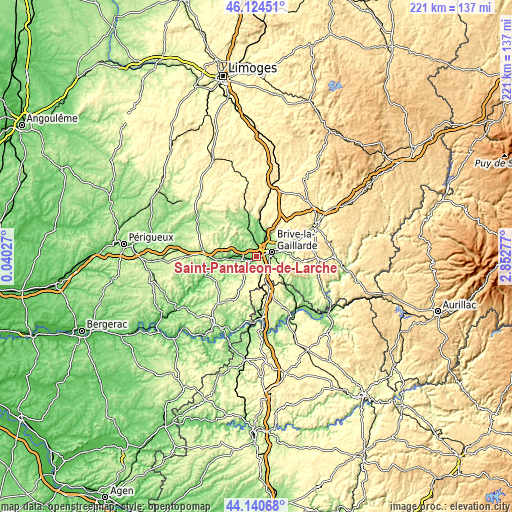
These maps also provides idea of topography and contour of this city, they are displayed at different zoom levels. More info about maps, scale and edge coordinates you can find below images.
| \ | Map #1 | Map #2 | Topo.Map |
| Scale [m] | 87..345 m | 84..354 m | × |
| Scale [ft] | 285..1132 ft | 276..1161 ft | × |
| Average | 147.5 m = 484 ft | 172.3 m = 565 ft | × |
| Width | 6.89 km = 4.3 mi | 13.79 km = 8.6 mi | 220.6 km = 137.1 mi |
| Height | 6.89 km = 4.3 mi | 13.79 km = 8.6 mi | 220.6 km = 137.1 mi |
| ↑Max Latitude | 45.172209° | 45.203181° | 46.12451° |
| Latitude at center | 45.14122° | 45.14122° | 45.14122° |
| ↓Min Latitude | 45.110214° | 45.079192° | 44.14068° |
| ← Min Longitude | 1.402575° | 1.358629° | 0.04027° |
| Longitude center | 1.44652° | 1.44652° | 1.44652° |
| →Max Longitude | 1.490465° | 1.534411° | 2.85277° |
Nearby cities:
Cities around Saint-Pantaléon-de-Larche sort by population:
• Brive-la-Gaillarde elevation 111 m
7.1 km,  73°
73°
• Malemort-sur-Corrèze 116 m
9.8 km, 70°
• Terrasson-Lavilledieu 87 m
11.5 km,  263°
263°
• Allassac 170 m
13.2 km,  9°
9°
• Ussac 207 m
7.9 km,  41°
41°
• Cosnac 239 m
10.9 km,  94°
94°
• Donzenac 210 m
11.3 km,  32°
32°
• Varetz 103 m
5.9 km,  3°
3°
• Cublac 111 m
11 km,  272°
272°
• Larche 117 m
3.3 km,  226°
226°
• Saint-Viance 105 m
8.5 km, 3°
• Mansac 195 m
5.8 km,  301°
301°
Multilingual:
 En español:
Saint-Pantaléon-de-Larche elevación 99 m.
 En France:
Saint-Pantaléon-de-Larche élévation 99 m.
 Auf Deutsch:
Saint-Pantaléon-de-Larche höhe über dem Meeresspiegel ist 99 m.
 На русском:
Saint-Pantaléon-de-Larche высота над уровнем моря 99 м
Sources and notes:
- [note 1] Map square and city borders are not equal. Map elevation data is calculated only from area inside that square.
- [src 1] Elevation data from geonames database provided with same terms of usage.
- [src 2] The elevation map of Saint-Pantaléon-de-Larche is generated using elevation data from NASA's 3 arcsec (90m) resolution SRTM data.
- [src 3] Base (background) map © OpenStreetMap contributors tiles are generated by Geofabrik and OpenTopoMap.
Copyright & License:
This Saint-Pantaléon-de-Larche Elevation Map is licensed under CC BY-SA. You may reuse any part from this page, if you give a proper credit by linking to this URL:
 More info on terms of use page.