Voutezac elevation
Voutezac (Nouvelle-Aquitaine, Département de la Corrèze), France elevation is 254 meters and Voutezac elevation in feet is 833 ft above sea level [src 1]. Voutezac is a populated place (feature code) with elevation that is 80 meters (262 ft) bigger than average city elevation in France.
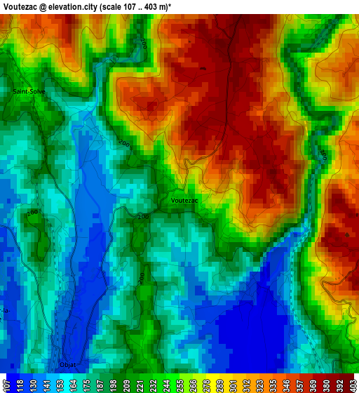
Below is the Elevation map of Voutezac, which displays elevation range with different colors. Scale of the first map is from 107 to 403 m (351 to 1322 ft) with average elevation of 233.6 meters (=766 ft) [note 1]
These maps also provides idea of topography and contour of this city, they are displayed at different zoom levels. More info about maps, scale and edge coordinates you can find below images.
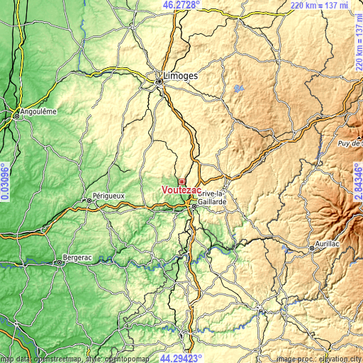
| \ | Map #1 | Topo.Map |
| Scale [m] | 107..403 m | × |
| Scale [ft] | 351..1322 ft | × |
| Average | 233.6 m = 766 ft | × |
| Width | 6.87 km = 4.3 mi | 220 km = 136.7 mi |
| Height | 6.87 km = 4.3 mi | 220 km = 136.7 mi |
| ↑Max Latitude | 45.323047° | 46.2728° |
| Latitude at center | 45.29214° | 45.29214° |
| ↓Min Latitude | 45.261216° | 44.29423° |
| ← Min Longitude | 1.393265° | 0.03096° |
| Longitude center | 1.43721° | 1.43721° |
| →Max Longitude | 1.481155° | 2.84346° |
Nearby cities:
Cities around Voutezac sort by population:
• Brive-la-Gaillarde elevation 111 m
16.6 km,  153°
153°
• Allassac 170 m
4.8 km,  141°
141°
• Objat 126 m
4 km,  214°
214°
• Ussac 207 m
12.4 km, 151°
• Donzenac 210 m
9.9 km, 136°
• Varetz 103 m
11 km,  174°
174°
• Sainte-Féréole 384 m
13.3 km,  121°
121°
• Saint-Viance 105 m
8.4 km, 171°
• Mansac 195 m
14.4 km,  197°
197°
• Arnac-Pompadour 360 m
14.1 km,  338°
338°
• Vigeois 343 m
11.5 km,  32°
32°
• Juillac 309 m
9.4 km,  287°
287°
Multilingual:
 En español:
Voutezac elevación 254 m.
 En France:
Voutezac élévation 254 m.
 Auf Deutsch:
Voutezac höhe über dem Meeresspiegel ist 254 m.

Sources and notes:
- [note 1] Map square and city borders are not equal. Map elevation data is calculated only from area inside that square.
- [src 1] Elevation data from geonames database provided with same terms of usage.
- [src 2] The elevation map of Voutezac is generated using elevation data from NASA's 3 arcsec (90m) resolution SRTM data.
- [src 3] Base (background) map © OpenStreetMap contributors tiles are generated by Geofabrik and OpenTopoMap.
Copyright & License:
This Voutezac Elevation Map is licensed under CC BY-SA. You may reuse any part from this page, if you give a proper credit by linking to this URL:
 More info on terms of use page.