Montignac elevation
Montignac (Nouvelle-Aquitaine, Dordogne), France elevation is 80 meters and Montignac elevation in feet is 262 ft above sea level [src 1]. Montignac is a populated place (feature code) with elevation that is 94 meters (308 ft) smaller than average city elevation in France.
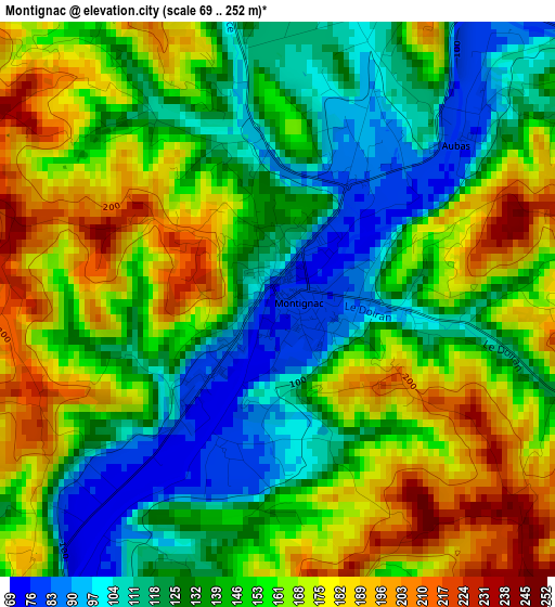
Below is the Elevation map of Montignac, which displays elevation range with different colors. Scale of the first map is from 69 to 252 m (226 to 827 ft) with average elevation of 147.8 meters (=485 ft) [note 1]
These maps also provides idea of topography and contour of this city, they are displayed at different zoom levels. More info about maps, scale and edge coordinates you can find below images.
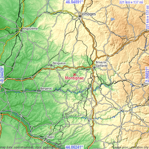
| \ | Map #1 | Topo.Map |
| Scale [m] | 69..252 m | × |
| Scale [ft] | 226..827 ft | × |
| Average | 147.8 m = 485 ft | × |
| Width | 6.9 km = 4.3 mi | 220.9 km = 137.3 mi |
| Height | 6.9 km = 4.3 mi | 220.9 km = 137.3 mi |
| ↑Max Latitude | 45.095321° | 46.04891° |
| Latitude at center | 45.06429° | 45.06429° |
| ↓Min Latitude | 45.033242° | 44.06241° |
| ← Min Longitude | 1.118015° | -0.24429° |
| Longitude center | 1.16196° | 1.16196° |
| →Max Longitude | 1.205905° | 2.56821° |
Nearby cities:
Cities around Montignac sort by population:
• Sarlat-la-Canéda elevation 147 m
20 km,  167°
167°
• Terrasson-Lavilledieu 87 m
13.2 km,  56°
56°
• Le Lardin-Saint-Lazare 104 m
8.8 km,  29°
29°
• Saint-Cyprien 69 m
23.7 km,  203°
203°
• Cublac 111 m
14.4 km,  51°
51°
• Rouffignac-Saint-Cernin-de-Reilhac 288 m
15.4 km,  264°
264°
• Larche 117 m
20.9 km,  72°
72°
• Mansac 195 m
20.9 km, 56°
• Thenon 260 m
10.9 km,  319°
319°
• Hautefort 204 m
21.7 km,  357°
357°
• Eyvigues-et-Eybènes 269 m
20.8 km,  134°
134°
• Salignac-Eyvigues 290 m
16.2 km, 128°
Multilingual:
 En español:
Montignac elevación 80 m.
 En France:
Montignac élévation 80 m.
 Auf Deutsch:
Montignac höhe über dem Meeresspiegel ist 80 m.

Sources and notes:
- [note 1] Map square and city borders are not equal. Map elevation data is calculated only from area inside that square.
- [src 1] Elevation data from geonames database provided with same terms of usage.
- [src 2] The elevation map of Montignac is generated using elevation data from NASA's 3 arcsec (90m) resolution SRTM data.
- [src 3] Base (background) map © OpenStreetMap contributors tiles are generated by Geofabrik and OpenTopoMap.
Copyright & License:
This Montignac Elevation Map is licensed under CC BY-SA. You may reuse any part from this page, if you give a proper credit by linking to this URL:
 More info on terms of use page.