Hautefort elevation
Hautefort (Nouvelle-Aquitaine, Dordogne), France elevation is 204 meters and Hautefort elevation in feet is 669 ft above sea level [src 1]. Hautefort is a populated place (feature code) with elevation that is 30 meters (98 ft) bigger than average city elevation in France.
Below is the Elevation map of Hautefort, which displays elevation range with different colors. Scale of the first map is from 136 to 302 m (446 to 991 ft) with average elevation of 201.4 meters (=661 ft) [note 1]
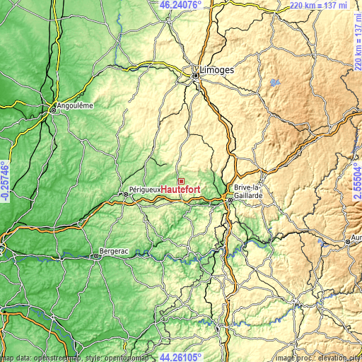
These maps also provides idea of topography and contour of this city, they are displayed at different zoom levels. More info about maps, scale and edge coordinates you can find below images.
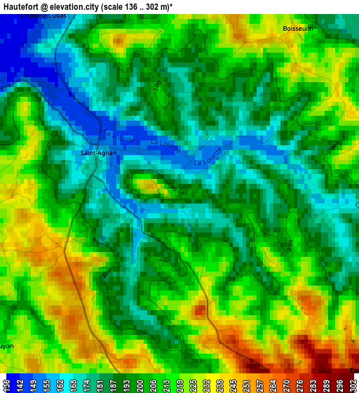
| \ | Map #1 | Topo.Map |
| Scale [m] | 136..302 m | × |
| Scale [ft] | 446..991 ft | × |
| Average | 201.4 m = 661 ft | × |
| Width | 6.88 km = 4.3 mi | 220.1 km = 136.8 mi |
| Height | 6.88 km = 4.3 mi | 220.1 km = 136.8 mi |
| ↑Max Latitude | 45.290455° | 46.24076° |
| Latitude at center | 45.25953° | 45.25953° |
| ↓Min Latitude | 45.228589° | 44.26105° |
| ← Min Longitude | 1.104845° | -0.25746° |
| Longitude center | 1.14879° | 1.14879° |
| →Max Longitude | 1.192735° | 2.55504° |
Nearby cities:
Cities around Hautefort sort by population:
• Terrasson-Lavilledieu elevation 87 m
18.7 km,  140°
140°
• Objat 126 m
20.3 km,  88°
88°
• Montignac 80 m
21.7 km,  177°
177°
• Le Lardin-Saint-Lazare 104 m
15 km,  159°
159°
• Cublac 111 m
17.7 km, 135°
• Excideuil 162 m
11.6 km,  317°
317°
• Mansac 195 m
21 km,  118°
118°
• Thenon 260 m
14.7 km,  204°
204°
• Sorges 178 m
22.2 km,  283°
283°
• Juillac 309 m
15.1 km,  64°
64°
• Payzac 354 m
16.5 km,  18°
18°
• Lanouaille 315 m
15.1 km,  357°
357°
Multilingual:
 En español:
Hautefort elevación 204 m.
 En France:
Hautefort élévation 204 m.
 Auf Deutsch:
Hautefort höhe über dem Meeresspiegel ist 204 m.

Sources and notes:
- [note 1] Map square and city borders are not equal. Map elevation data is calculated only from area inside that square.
- [src 1] Elevation data from geonames database provided with same terms of usage.
- [src 2] The elevation map of Hautefort is generated using elevation data from NASA's 3 arcsec (90m) resolution SRTM data.
- [src 3] Base (background) map © OpenStreetMap contributors tiles are generated by Geofabrik and OpenTopoMap.
Copyright & License:
This Hautefort Elevation Map is licensed under CC BY-SA. You may reuse any part from this page, if you give a proper credit by linking to this URL:
 More info on terms of use page.