Noyant-la-Gravoyère elevation
Noyant-la-Gravoyère (Pays de la Loire, Département de Maine-et-Loire), France elevation is 95 meters and Noyant-la-Gravoyère elevation in feet is 312 ft above sea level [src 1]. Noyant-la-Gravoyère is a populated place (feature code) with elevation that is 79 meters (259 ft) smaller than average city elevation in France.
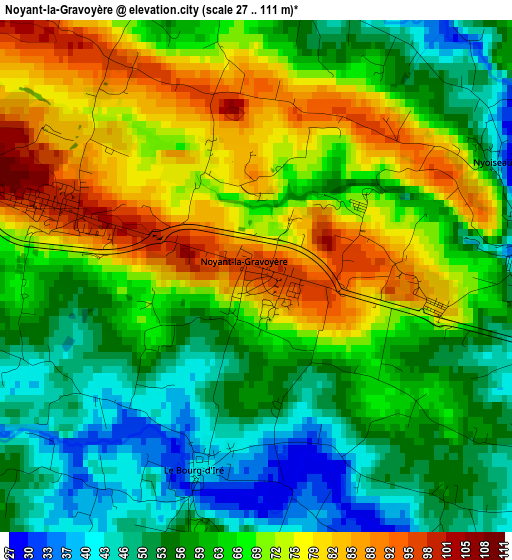
Below is the Elevation map of Noyant-la-Gravoyère, which displays elevation range with different colors. Scale of the first map is from 27 to 111 m (89 to 364 ft) with average elevation of 64.5 meters (=212 ft) [note 1]
These maps also provides idea of topography and contour of this city, they are displayed at different zoom levels. More info about maps, scale and edge coordinates you can find below images.
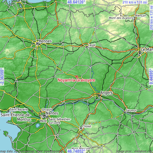
| \ | Map #1 | Topo.Map |
| Scale [m] | 27..111 m | × |
| Scale [ft] | 89..364 ft | × |
| Average | 64.5 m = 212 ft | × |
| Width | 6.58 km = 4.1 mi | 210.5 km = 130.8 mi |
| Height | 6.58 km = 4.1 mi | 210.4 km = 130.7 mi |
| ↑Max Latitude | 47.733045° | 48.64126° |
| Latitude at center | 47.70348° | 47.70348° |
| ↓Min Latitude | 47.673898° | 46.74852° |
| ← Min Longitude | -1.001245° | -2.36355° |
| Longitude center | -0.9573° | -0.9573° |
| →Max Longitude | -0.913355° | 0.44895° |
Nearby cities:
Cities around Noyant-la-Gravoyère sort by population:
• Segré elevation 47 m
6.6 km,  106°
106°
• Craon 53 m
16 km,  2°
2°
• Pouancé 85 m
16.7 km,  284°
284°
• Renazé 72 m
12.4 km,  324°
324°
• Candé 47 m
16.8 km,  200°
200°
• Combrée 55 m
5.4 km,  271°
271°
• Vern-d’Anjou 46 m
14.7 km,  140°
140°
• Saint-Fort 67 m
20.6 km,  58°
58°
• Nyoiseau 43 m
3.4 km, 64°
• La Pouëze 68 m
20 km,  146°
146°
• Congrier 83 m
16.8 km,  314°
314°
• Chemazé 88 m
16.5 km, 55°
Multilingual:
 En español:
Noyant-la-Gravoyère elevación 95 m.
 En France:
Noyant-la-Gravoyère élévation 95 m.
 Auf Deutsch:
Noyant-la-Gravoyère höhe über dem Meeresspiegel ist 95 m.
 На русском:
Noyant-la-Gravoyère высота над уровнем моря 95 м
Sources and notes:
- [note 1] Map square and city borders are not equal. Map elevation data is calculated only from area inside that square.
- [src 1] Elevation data from geonames database provided with same terms of usage.
- [src 2] The elevation map of Noyant-la-Gravoyère is generated using elevation data from NASA's 3 arcsec (90m) resolution SRTM data.
- [src 3] Base (background) map © OpenStreetMap contributors tiles are generated by Geofabrik and OpenTopoMap.
Copyright & License:
This Noyant-la-Gravoyère Elevation Map is licensed under CC BY-SA. You may reuse any part from this page, if you give a proper credit by linking to this URL:
 More info on terms of use page.