La Pouëze elevation
La Pouëze (Pays de la Loire, Département de Maine-et-Loire), France elevation is 68 meters and La Pouëze elevation in feet is 223 ft above sea level [src 1]. La Pouëze is a populated place (feature code) with elevation that is 106 meters (348 ft) smaller than average city elevation in France.
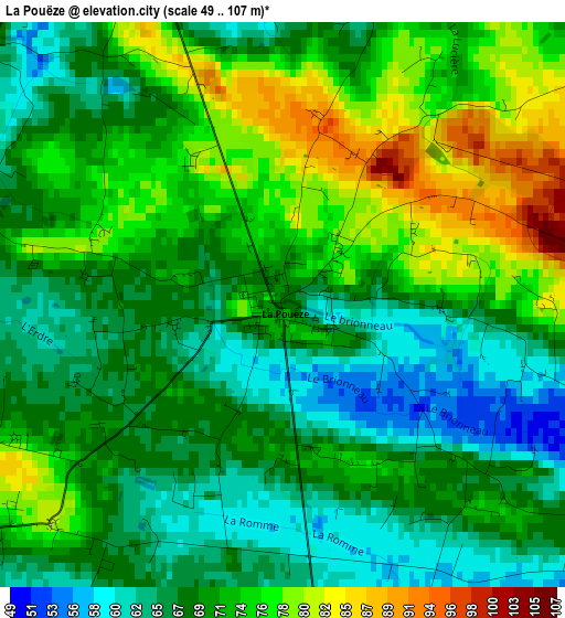
Below is the Elevation map of La Pouëze, which displays elevation range with different colors. Scale of the first map is from 49 to 107 m (161 to 351 ft) with average elevation of 70.6 meters (=232 ft) [note 1]
These maps also provides idea of topography and contour of this city, they are displayed at different zoom levels. More info about maps, scale and edge coordinates you can find below images.
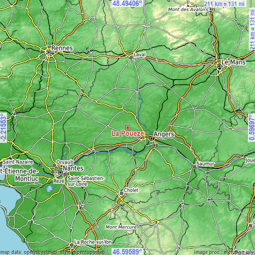
| \ | Map #1 | Topo.Map |
| Scale [m] | 49..107 m | × |
| Scale [ft] | 161..351 ft | × |
| Average | 70.6 m = 232 ft | × |
| Width | 6.6 km = 4.1 mi | 211.1 km = 131.2 mi |
| Height | 6.6 km = 4.1 mi | 211 km = 131.1 mi |
| ↑Max Latitude | 47.58322° | 48.49406° |
| Latitude at center | 47.55357° | 47.55357° |
| ↓Min Latitude | 47.523903° | 46.59589° |
| ← Min Longitude | -0.853225° | -2.21553° |
| Longitude center | -0.80928° | -0.80928° |
| →Max Longitude | -0.765335° | 0.59697° |
Nearby cities:
Cities around La Pouëze sort by population:
• Segré elevation 47 m
15.5 km,  342°
342°
• Bécon-les-Granits 58 m
5.8 km,  173°
173°
• Saint-Lambert-la-Potherie 60 m
12.6 km,  128°
128°
• Le Louroux-Béconnais 76 m
6.8 km,  238°
238°
• La Meignanne 35 m
11.3 km,  111°
111°
• Vern-d’Anjou 46 m
5.6 km, 341°
• La Membrolle-sur-Longuenée 55 m
10.3 km,  86°
86°
• Saint-Léger-des-Bois 62 m
12.6 km,  143°
143°
• Saint-Clément-de-la-Place 64 m
5.6 km,  121°
121°
• Saint-Martin-du-Fouilloux 71 m
15.5 km,  149°
149°
• Grez-Neuville 27 m
11 km,  60°
60°
• Le Plessis-Macé 84 m
10.2 km,  96°
96°
Multilingual:
 En español:
La Pouëze elevación 68 m.
 En France:
La Pouëze élévation 68 m.
 Auf Deutsch:
La Pouëze höhe über dem Meeresspiegel ist 68 m.

Sources and notes:
- [note 1] Map square and city borders are not equal. Map elevation data is calculated only from area inside that square.
- [src 1] Elevation data from geonames database provided with same terms of usage.
- [src 2] The elevation map of La Pouëze is generated using elevation data from NASA's 3 arcsec (90m) resolution SRTM data.
- [src 3] Base (background) map © OpenStreetMap contributors tiles are generated by Geofabrik and OpenTopoMap.
Copyright & License:
This La Pouëze Elevation Map is licensed under CC BY-SA. You may reuse any part from this page, if you give a proper credit by linking to this URL:
 More info on terms of use page.