Piégut-Pluviers elevation
Piégut-Pluviers (Nouvelle-Aquitaine, Dordogne), France elevation is 289 meters and Piégut-Pluviers elevation in feet is 948 ft above sea level [src 1]. Piégut-Pluviers is a populated place (feature code) with elevation that is 115 meters (377 ft) bigger than average city elevation in France.
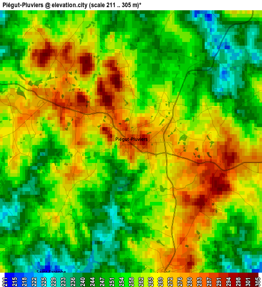
Below is the Elevation map of Piégut-Pluviers, which displays elevation range with different colors. Scale of the first map is from 211 to 305 m (692 to 1001 ft) with average elevation of 259.7 meters (=852 ft) [note 1]
These maps also provides idea of topography and contour of this city, they are displayed at different zoom levels. More info about maps, scale and edge coordinates you can find below images.
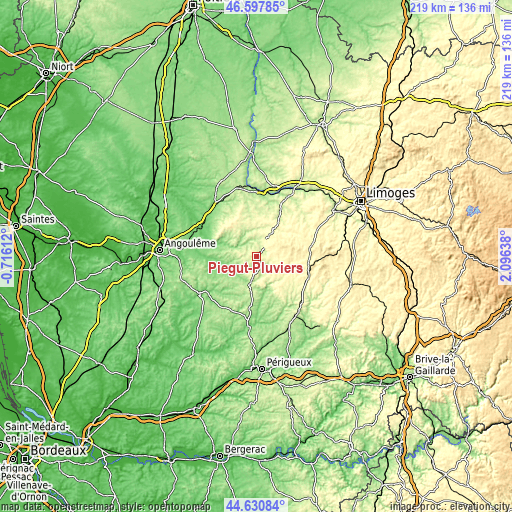
| \ | Map #1 | Topo.Map |
| Scale [m] | 211..305 m | × |
| Scale [ft] | 692..1001 ft | × |
| Average | 259.7 m = 852 ft | × |
| Width | 6.83 km = 4.2 mi | 218.7 km = 135.9 mi |
| Height | 6.83 km = 4.2 mi | 218.7 km = 135.9 mi |
| ↑Max Latitude | 45.653696° | 46.59785° |
| Latitude at center | 45.62297° | 45.62297° |
| ↓Min Latitude | 45.592227° | 44.63084° |
| ← Min Longitude | 0.646185° | -0.71612° |
| Longitude center | 0.69013° | 0.69013° |
| →Max Longitude | 0.734075° | 2.09638° |
Nearby cities:
Cities around Piégut-Pluviers sort by population:
• Rochechouart elevation 214 m
24.5 km,  24°
24°
• Nontron 214 m
10.6 km,  191°
191°
• Montbron 142 m
15.6 km,  288°
288°
• Châlus 385 m
22.8 km,  81°
81°
• Oradour-sur-Vayres 352 m
18.3 km,  48°
48°
• Saint-Laurent-sur-Gorre 262 m
26.4 km, 51°
• Chazelles 96 m
25.2 km,  276°
276°
• La Coquille 343 m
24.1 km,  111°
111°
• Cussac 344 m
15.5 km, 53°
• Saint-Mathieu 324 m
10.7 km,  29°
29°
• Mareuil 118 m
26.8 km,  224°
224°
• Saint-Pardoux-la-Rivière 144 m
15 km,  162°
162°
Multilingual:
 En español:
Piégut-Pluviers elevación 289 m.
 En France:
Piégut-Pluviers élévation 289 m.
 Auf Deutsch:
Piégut-Pluviers höhe über dem Meeresspiegel ist 289 m.

Sources and notes:
- [note 1] Map square and city borders are not equal. Map elevation data is calculated only from area inside that square.
- [src 1] Elevation data from geonames database provided with same terms of usage.
- [src 2] The elevation map of Piégut-Pluviers is generated using elevation data from NASA's 3 arcsec (90m) resolution SRTM data.
- [src 3] Base (background) map © OpenStreetMap contributors tiles are generated by Geofabrik and OpenTopoMap.
Copyright & License:
This Piégut-Pluviers Elevation Map is licensed under CC BY-SA. You may reuse any part from this page, if you give a proper credit by linking to this URL:
 More info on terms of use page.