Saint-Pardoux-la-Rivière elevation
Saint-Pardoux-la-Rivière (Nouvelle-Aquitaine, Dordogne), France elevation is 144 meters and Saint-Pardoux-la-Rivière elevation in feet is 472 ft above sea level [src 1]. Saint-Pardoux-la-Rivière is a populated place (feature code) with elevation that is 30 meters (98 ft) smaller than average city elevation in France.
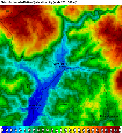
Below is the Elevation map of Saint-Pardoux-la-Rivière, which displays elevation range with different colors. Scale of the first map is from 126 to 310 m (413 to 1017 ft) with average elevation of 209.1 meters (=686 ft) [note 1]
These maps also provides idea of topography and contour of this city, they are displayed at different zoom levels. More info about maps, scale and edge coordinates you can find below images.
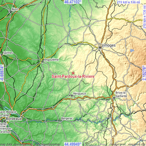
| \ | Map #1 | Topo.Map |
| Scale [m] | 126..310 m | × |
| Scale [ft] | 413..1017 ft | × |
| Average | 209.1 m = 686 ft | × |
| Width | 6.85 km = 4.3 mi | 219.2 km = 136.2 mi |
| Height | 6.85 km = 4.3 mi | 219.2 km = 136.2 mi |
| ↑Max Latitude | 45.524677° | 46.47102° |
| Latitude at center | 45.49388° | 45.49388° |
| ↓Min Latitude | 45.463067° | 44.49949° |
| ← Min Longitude | 0.702565° | -0.65974° |
| Longitude center | 0.74651° | 0.74651° |
| →Max Longitude | 0.790455° | 2.15276° |
Nearby cities:
Cities around Saint-Pardoux-la-Rivière sort by population:
• Nontron elevation 214 m
7.7 km,  300°
300°
• Thiviers 273 m
16.1 km,  122°
122°
• Brantôme 117 m
16.5 km,  206°
206°
• Châlus 385 m
25.5 km,  45°
45°
• Agonac 137 m
22.4 km,  179°
179°
• Piégut-Pluviers 289 m
15 km,  342°
342°
• La Coquille 343 m
18.7 km,  73°
73°
• Jumilhac-le-Grand 283 m
24.7 km,  89°
89°
• Cussac 344 m
25 km,  18°
18°
• Saint-Mathieu 324 m
23.6 km,  2°
2°
• Mareuil 118 m
23.6 km,  258°
258°
• Sorges 178 m
23.2 km,  154°
154°
Multilingual:
 En español:
Saint-Pardoux-la-Rivière elevación 144 m.
 En France:
Saint-Pardoux-la-Rivière élévation 144 m.
 Auf Deutsch:
Saint-Pardoux-la-Rivière höhe über dem Meeresspiegel ist 144 m.
 На русском:
Сен-Парду-ла-Ривьер высота над уровнем моря 144 м
Sources and notes:
- [note 1] Map square and city borders are not equal. Map elevation data is calculated only from area inside that square.
- [src 1] Elevation data from geonames database provided with same terms of usage.
- [src 2] The elevation map of Saint-Pardoux-la-Rivière is generated using elevation data from NASA's 3 arcsec (90m) resolution SRTM data.
- [src 3] Base (background) map © OpenStreetMap contributors tiles are generated by Geofabrik and OpenTopoMap.
Copyright & License:
This Saint-Pardoux-la-Rivière Elevation Map is licensed under CC BY-SA. You may reuse any part from this page, if you give a proper credit by linking to this URL:
 More info on terms of use page.