Agonac elevation
Agonac (Nouvelle-Aquitaine, Dordogne), France elevation is 137 meters and Agonac elevation in feet is 449 ft above sea level [src 1]. Agonac is a populated place (feature code) with elevation that is 37 meters (121 ft) smaller than average city elevation in France.
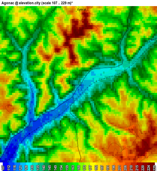
Below is the Elevation map of Agonac, which displays elevation range with different colors. Scale of the first map is from 107 to 229 m (351 to 751 ft) with average elevation of 164.8 meters (=541 ft) [note 1]
These maps also provides idea of topography and contour of this city, they are displayed at different zoom levels. More info about maps, scale and edge coordinates you can find below images.
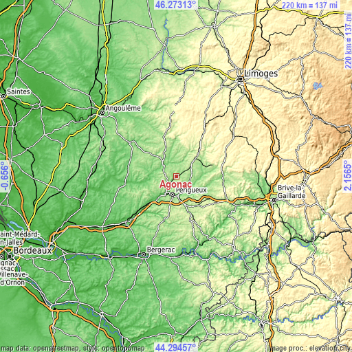
| \ | Map #1 | Topo.Map |
| Scale [m] | 107..229 m | × |
| Scale [ft] | 351..751 ft | × |
| Average | 164.8 m = 541 ft | × |
| Width | 6.87 km = 4.3 mi | 220 km = 136.7 mi |
| Height | 6.87 km = 4.3 mi | 220 km = 136.7 mi |
| ↑Max Latitude | 45.323387° | 46.27313° |
| Latitude at center | 45.29248° | 45.29248° |
| ↓Min Latitude | 45.261557° | 44.29457° |
| ← Min Longitude | 0.706305° | -0.656° |
| Longitude center | 0.75025° | 0.75025° |
| →Max Longitude | 0.794195° | 2.1565° |
Nearby cities:
Cities around Agonac sort by population:
• Périgueux elevation 103 m
12.4 km,  192°
192°
• Coulounieix-Chamiers 179 m
16.3 km,  197°
197°
• Trélissac 96 m
10.9 km,  165°
165°
• Chancelade 83 m
11.9 km,  210°
210°
• Champcevinel 198 m
8.6 km, 191°
• Razac-sur-l’Isle 90 m
18.5 km,  219°
219°
• Brantôme 117 m
10.7 km,  315°
315°
• Bassillac 106 m
12.2 km,  155°
155°
• Atur 231 m
16.9 km,  180°
180°
• Mensignac 202 m
16.5 km,  243°
243°
• Sorges 178 m
9.7 km,  81°
81°
• Antonne-et-Trigonant 109 m
10.8 km,  144°
144°
Multilingual:
 En español:
Agonac elevación 137 m.
 En France:
Agonac élévation 137 m.


Sources and notes:
- [note 1] Map square and city borders are not equal. Map elevation data is calculated only from area inside that square.
- [src 1] Elevation data from geonames database provided with same terms of usage.
- [src 2] The elevation map of Agonac is generated using elevation data from NASA's 3 arcsec (90m) resolution SRTM data.
- [src 3] Base (background) map © OpenStreetMap contributors tiles are generated by Geofabrik and OpenTopoMap.
Copyright & License:
This Agonac Elevation Map is licensed under CC BY-SA. You may reuse any part from this page, if you give a proper credit by linking to this URL:
 More info on terms of use page.