Coulounieix-Chamiers elevation
Coulounieix-Chamiers (Nouvelle-Aquitaine, Dordogne), France elevation is 179 meters and Coulounieix-Chamiers elevation in feet is 587 ft above sea level [src 1]. Coulounieix-Chamiers is a populated place (feature code) with elevation that is 5 meters (16 ft) bigger than average city elevation in France.
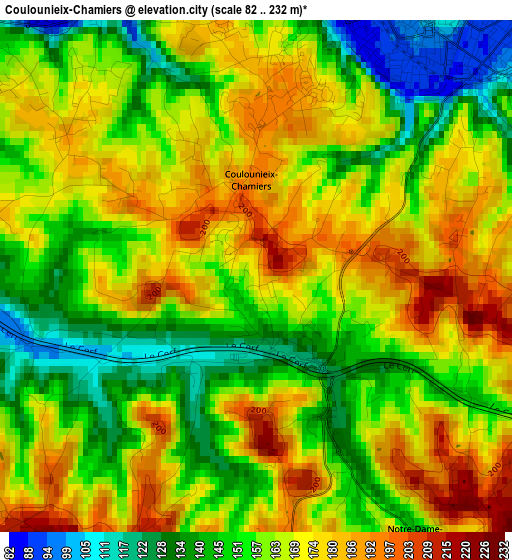
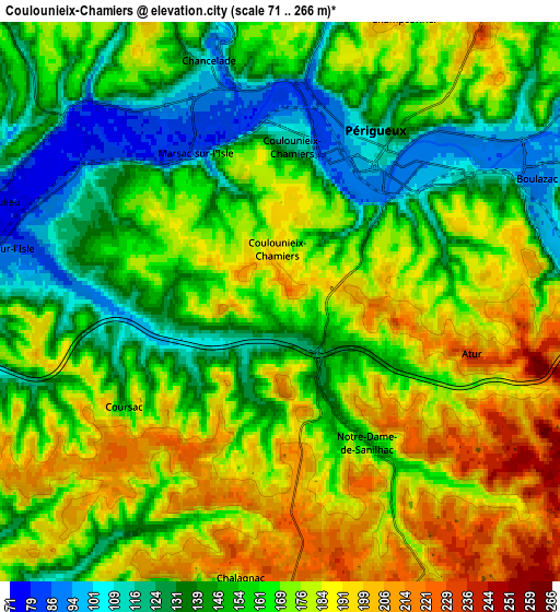
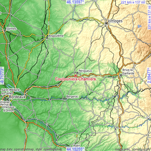
Below is the Elevation map of Coulounieix-Chamiers, which displays elevation range with different colors. Scale of the first map is from 82 to 232 m (269 to 761 ft) with average elevation of 162.5 meters (=533 ft) [note 1]
These maps also provides idea of topography and contour of this city, they are displayed at different zoom levels. More info about maps, scale and edge coordinates you can find below images.
| \ | Map #1 | Map #2 | Topo.Map |
| Scale [m] | 82..232 m | 71..266 m | × |
| Scale [ft] | 269..761 ft | 233..873 ft | × |
| Average | 162.5 m = 533 ft | 163 m = 535 ft | × |
| Width | 6.89 km = 4.3 mi | 13.78 km = 8.6 mi | 220.5 km = 137 mi |
| Height | 6.89 km = 4.3 mi | 13.78 km = 8.6 mi | 220.5 km = 137 mi |
| ↑Max Latitude | 45.183873° | 45.214838° | 46.13597° |
| Latitude at center | 45.15289° | 45.15289° | 45.15289° |
| ↓Min Latitude | 45.121891° | 45.090874° | 44.15255° |
| ← Min Longitude | 0.644575° | 0.600629° | -0.71773° |
| Longitude center | 0.68852° | 0.68852° | 0.68852° |
| →Max Longitude | 0.732465° | 0.776411° | 2.09477° |
Nearby cities:
Cities around Coulounieix-Chamiers sort by population:
• Périgueux elevation 103 m
4 km,  33°
33°
• Trélissac 96 m
9.1 km,  56°
56°
• Boulazac 235 m
6.3 km,  129°
129°
• Chancelade 83 m
5.4 km,  346°
346°
• Notre-Dame-de-Sanilhac 169 m
4 km,  152°
152°
• Champcevinel 198 m
7.7 km,  23°
23°
• Razac-sur-l’Isle 90 m
7 km,  279°
279°
• Bassillac 106 m
10.9 km,  65°
65°
• Atur 231 m
4.8 km,  106°
106°
• Coursac 156 m
4.7 km,  235°
235°
• Annesse-et-Beaulieu 73 m
9.2 km, 277°
• Montrem 156 m
8 km,  254°
254°
Multilingual:
 En español:
Coulounieix-Chamiers elevación 179 m.
 En France:
Coulounieix-Chamiers élévation 179 m.
 Auf Deutsch:
Coulounieix-Chamiers höhe über dem Meeresspiegel ist 179 m.

Sources and notes:
- [note 1] Map square and city borders are not equal. Map elevation data is calculated only from area inside that square.
- [src 1] Elevation data from geonames database provided with same terms of usage.
- [src 2] The elevation map of Coulounieix-Chamiers is generated using elevation data from NASA's 3 arcsec (90m) resolution SRTM data.
- [src 3] Base (background) map © OpenStreetMap contributors tiles are generated by Geofabrik and OpenTopoMap.
Copyright & License:
This Coulounieix-Chamiers Elevation Map is licensed under CC BY-SA. You may reuse any part from this page, if you give a proper credit by linking to this URL:
 More info on terms of use page.