Thiviers elevation
Thiviers (Nouvelle-Aquitaine, Dordogne), France elevation is 273 meters and Thiviers elevation in feet is 896 ft above sea level [src 1]. Thiviers is a populated place (feature code) with elevation that is 99 meters (325 ft) bigger than average city elevation in France.
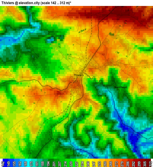
Below is the Elevation map of Thiviers, which displays elevation range with different colors. Scale of the first map is from 142 to 312 m (466 to 1024 ft) with average elevation of 230.6 meters (=757 ft) [note 1]
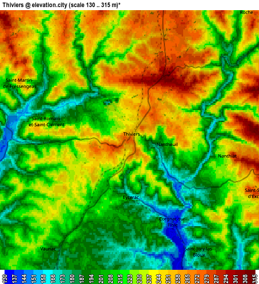
These maps also provides idea of topography and contour of this city, they are displayed at different zoom levels. More info about maps, scale and edge coordinates you can find below images.
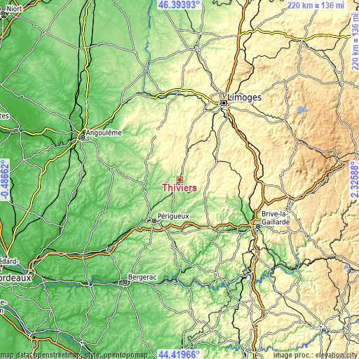
| \ | Map #1 | Map #2 | Topo.Map |
| Scale [m] | 142..312 m | 130..315 m | × |
| Scale [ft] | 466..1024 ft | 427..1033 ft | × |
| Average | 230.6 m = 757 ft | 223.5 m = 733 ft | × |
| Width | 6.86 km = 4.3 mi | 13.72 km = 8.5 mi | 219.5 km = 136.4 mi |
| Height | 6.86 km = 4.3 mi | 13.72 km = 8.5 mi | 219.5 km = 136.4 mi |
| ↑Max Latitude | 45.446259° | 45.477082° | 46.39393° |
| Latitude at center | 45.41542° | 45.41542° | 45.41542° |
| ↓Min Latitude | 45.384564° | 45.35369° | 44.41966° |
| ← Min Longitude | 0.875685° | 0.831739° | -0.48662° |
| Longitude center | 0.91963° | 0.91963° | 0.91963° |
| →Max Longitude | 0.963575° | 1.007521° | 2.32588° |
Nearby cities:
Cities around Thiviers sort by population:
• Nontron elevation 214 m
23.8 km,  302°
302°
• Brantôme 117 m
21.6 km,  253°
253°
• Agonac 137 m
19 km,  224°
224°
• Excideuil 162 m
13.3 km,  131°
131°
• La Coquille 343 m
14.8 km,  17°
17°
• Jumilhac-le-Grand 283 m
14.2 km,  51°
51°
• Sorges 178 m
12.7 km,  196°
196°
• Antonne-et-Trigonant 109 m
23.6 km, 197°
• Saint-Pardoux-la-Rivière 144 m
16.1 km, 302°
• Ladignac-le-Long 394 m
24 km,  39°
39°
• Payzac 354 m
23.3 km,  94°
94°
• Lanouaille 315 m
17.3 km,  97°
97°
Multilingual:
 En español:
Thiviers elevación 273 m.
 En France:
Thiviers élévation 273 m.
 Auf Deutsch:
Thiviers höhe über dem Meeresspiegel ist 273 m.

Sources and notes:
- [note 1] Map square and city borders are not equal. Map elevation data is calculated only from area inside that square.
- [src 1] Elevation data from geonames database provided with same terms of usage.
- [src 2] The elevation map of Thiviers is generated using elevation data from NASA's 3 arcsec (90m) resolution SRTM data.
- [src 3] Base (background) map © OpenStreetMap contributors tiles are generated by Geofabrik and OpenTopoMap.
Copyright & License:
This Thiviers Elevation Map is licensed under CC BY-SA. You may reuse any part from this page, if you give a proper credit by linking to this URL:
 More info on terms of use page.