Mareuil elevation
Mareuil (Nouvelle-Aquitaine, Dordogne), France elevation is 118 meters and Mareuil elevation in feet is 387 ft above sea level [src 1]. Mareuil is a populated place (feature code) with elevation that is 56 meters (184 ft) smaller than average city elevation in France.
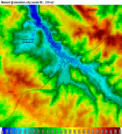
Below is the Elevation map of Mareuil, which displays elevation range with different colors. Scale of the first map is from 98 to 210 m (322 to 689 ft) with average elevation of 154.7 meters (=508 ft) [note 1]
These maps also provides idea of topography and contour of this city, they are displayed at different zoom levels. More info about maps, scale and edge coordinates you can find below images.
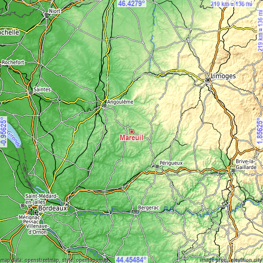
| \ | Map #1 | Topo.Map |
| Scale [m] | 98..210 m | × |
| Scale [ft] | 322..689 ft | × |
| Average | 154.7 m = 508 ft | × |
| Width | 6.86 km = 4.3 mi | 219.4 km = 136.3 mi |
| Height | 6.86 km = 4.3 mi | 219.4 km = 136.3 mi |
| ↑Max Latitude | 45.480821° | 46.4279° |
| Latitude at center | 45.45° | 45.45° |
| ↓Min Latitude | 45.419163° | 44.45484° |
| ← Min Longitude | 0.406055° | -0.95625° |
| Longitude center | 0.45° | 0.45° |
| →Max Longitude | 0.493945° | 1.85625° |
Nearby cities:
Cities around Mareuil sort by population:
• Ribérac elevation 92 m
24 km,  202°
202°
• Nontron 214 m
18.7 km,  61°
61°
• Montbron 142 m
24.4 km,  9°
9°
• Brantôme 117 m
18.8 km,  121°
121°
• Garat 72 m
24.9 km,  324°
324°
• Tocane-Saint-Apre 81 m
22.1 km,  170°
170°
• Chazelles 96 m
22.8 km,  343°
343°
• Dirac 139 m
22.8 km, 316°
• Dignac 177 m
17.1 km,  310°
310°
• Mensignac 202 m
26.5 km,  160°
160°
• Montmoreau-Saint-Cybard 81 m
25.3 km,  257°
257°
• Saint-Pardoux-la-Rivière 144 m
23.6 km,  78°
78°
Multilingual:
 En español:
Mareuil elevación 118 m.
 En France:
Mareuil élévation 118 m.


Sources and notes:
- [note 1] Map square and city borders are not equal. Map elevation data is calculated only from area inside that square.
- [src 1] Elevation data from geonames database provided with same terms of usage.
- [src 2] The elevation map of Mareuil is generated using elevation data from NASA's 3 arcsec (90m) resolution SRTM data.
- [src 3] Base (background) map © OpenStreetMap contributors tiles are generated by Geofabrik and OpenTopoMap.
Copyright & License:
This Mareuil Elevation Map is licensed under CC BY-SA. You may reuse any part from this page, if you give a proper credit by linking to this URL:
 More info on terms of use page.